You are here: Home > Network List > TA - USArray Transportable Network (new EarthScope stations) Stations List
> Station P23K Montague Island, AK, USA > Earthquake Result Viewer
P23K Montague Island, AK, USA - Earthquake Result Viewer
| Earthquake location: |
New Britain Region, P.N.G. |
| Earthquake latitude/longitude: |
-4.1/152.6 |
| Earthquake time(UTC): |
2019/05/14 (134) 12:58:26 GMT |
| Earthquake Depth: |
10 km |
| Earthquake Magnitude: |
7.5 Mww |
| Earthquake Catalog/Contributor: |
NEIC PDE/us |
|
| Network: |
TA USArray Transportable Network (new EarthScope stations) |
| Station: |
P23K Montague Island, AK, USA |
| Lat/Lon: |
60.00 N/147.40 W |
| Elevation: |
287 m |
|
| Distance: |
79.1 deg |
| Az: |
26.319 deg |
| Baz: |
241.644 deg |
| Ray Param: |
0.049201593 |
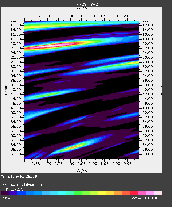
| Estimated Moho Depth: |
20.5 km |
| Estimated Crust Vp/Vs: |
1.73 |
| Assumed Crust Vp: |
5.989 km/s |
| Estimated Crust Vs: |
3.467 km/s |
| Estimated Crust Poisson's Ratio: |
0.25 |
|
| Radial Match: |
91.26126 % |
| Radial Bump: |
400 |
| Transverse Match: |
84.02273 % |
| Transverse Bump: |
400 |
| SOD ConfigId: |
18369291 |
| Insert Time: |
2019-05-28 13:04:25.770 +0000 |
| GWidth: |
2.5 |
| Max Bumps: |
400 |
| Tol: |
0.001 |
|

Signal To Noise
| Channel | StoN | STA | LTA |
| TA:P23K: :BHZ:20190514T13:09:59.149989Z | 5.0398703 | 1.1247013E-6 | 2.2316075E-7 |
| TA:P23K: :BHN:20190514T13:09:59.149989Z | 0.7243806 | 2.1080113E-7 | 2.9100877E-7 |
| TA:P23K: :BHE:20190514T13:09:59.149989Z | 1.5988612 | 3.505721E-7 | 2.1926361E-7 |
| Arrivals |
| Ps | 2.6 SECOND |
| PpPs | 9.1 SECOND |
| PsPs/PpSs | 12 SECOND |


