You are here: Home > Network List > TA - USArray Transportable Network (new EarthScope stations) Stations List
> Station R18K Karluk, AK, USA > Earthquake Result Viewer
R18K Karluk, AK, USA - Earthquake Result Viewer
| Earthquake location: |
New Britain Region, P.N.G. |
| Earthquake latitude/longitude: |
-4.1/152.6 |
| Earthquake time(UTC): |
2019/05/14 (134) 12:58:26 GMT |
| Earthquake Depth: |
10 km |
| Earthquake Magnitude: |
7.5 Mww |
| Earthquake Catalog/Contributor: |
NEIC PDE/us |
|
| Network: |
TA USArray Transportable Network (new EarthScope stations) |
| Station: |
R18K Karluk, AK, USA |
| Lat/Lon: |
57.57 N/154.45 W |
| Elevation: |
39 m |
|
| Distance: |
74.7 deg |
| Az: |
26.493 deg |
| Baz: |
235.662 deg |
| Ray Param: |
0.052166928 |
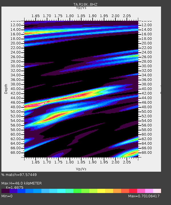
| Estimated Moho Depth: |
46.0 km |
| Estimated Crust Vp/Vs: |
1.69 |
| Assumed Crust Vp: |
6.24 km/s |
| Estimated Crust Vs: |
3.698 km/s |
| Estimated Crust Poisson's Ratio: |
0.23 |
|
| Radial Match: |
97.57449 % |
| Radial Bump: |
306 |
| Transverse Match: |
93.42024 % |
| Transverse Bump: |
400 |
| SOD ConfigId: |
18369291 |
| Insert Time: |
2019-05-28 13:04:32.743 +0000 |
| GWidth: |
2.5 |
| Max Bumps: |
400 |
| Tol: |
0.001 |
|
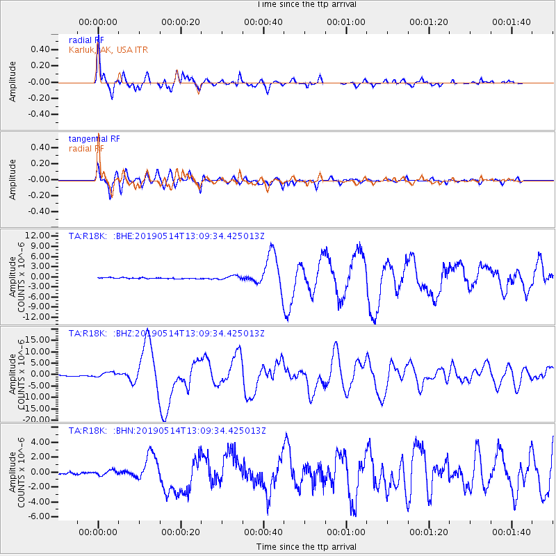
Signal To Noise
| Channel | StoN | STA | LTA |
| TA:R18K: :BHZ:20190514T13:09:34.425013Z | 6.526381 | 1.1144634E-6 | 1.7076285E-7 |
| TA:R18K: :BHN:20190514T13:09:34.425013Z | 2.6843956 | 3.385839E-7 | 1.261304E-7 |
| TA:R18K: :BHE:20190514T13:09:34.425013Z | 4.0579324 | 5.6425614E-7 | 1.3905016E-7 |
| Arrivals |
| Ps | 5.2 SECOND |
| PpPs | 19 SECOND |
| PsPs/PpSs | 24 SECOND |


