You are here: Home > Network List > TA - USArray Transportable Network (new EarthScope stations) Stations List
> Station R32K Eaglecrest, AK, USA > Earthquake Result Viewer
R32K Eaglecrest, AK, USA - Earthquake Result Viewer
| Earthquake location: |
New Britain Region, P.N.G. |
| Earthquake latitude/longitude: |
-4.1/152.6 |
| Earthquake time(UTC): |
2019/05/14 (134) 12:58:26 GMT |
| Earthquake Depth: |
10 km |
| Earthquake Magnitude: |
7.5 Mww |
| Earthquake Catalog/Contributor: |
NEIC PDE/us |
|
| Network: |
TA USArray Transportable Network (new EarthScope stations) |
| Station: |
R32K Eaglecrest, AK, USA |
| Lat/Lon: |
58.27 N/134.52 W |
| Elevation: |
386 m |
|
| Distance: |
84.6 deg |
| Az: |
30.489 deg |
| Baz: |
253.292 deg |
| Ray Param: |
0.04539764 |
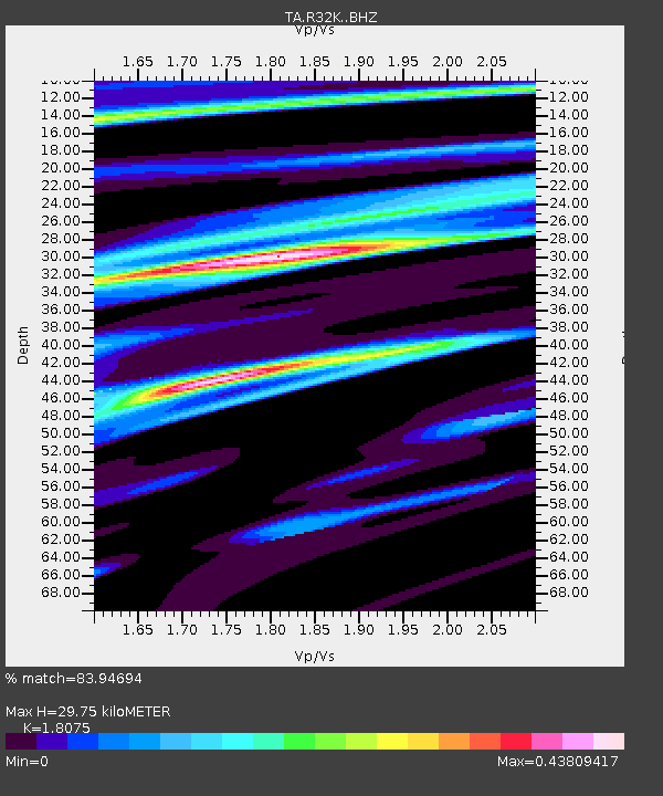
| Estimated Moho Depth: |
29.75 km |
| Estimated Crust Vp/Vs: |
1.81 |
| Assumed Crust Vp: |
6.566 km/s |
| Estimated Crust Vs: |
3.633 km/s |
| Estimated Crust Poisson's Ratio: |
0.28 |
|
| Radial Match: |
83.94694 % |
| Radial Bump: |
400 |
| Transverse Match: |
71.41532 % |
| Transverse Bump: |
400 |
| SOD ConfigId: |
18369291 |
| Insert Time: |
2019-05-28 13:04:32.973 +0000 |
| GWidth: |
2.5 |
| Max Bumps: |
400 |
| Tol: |
0.001 |
|

Signal To Noise
| Channel | StoN | STA | LTA |
| TA:R32K: :BHZ:20190514T13:10:27.850001Z | 4.1722937 | 6.4718944E-7 | 1.5511597E-7 |
| TA:R32K: :BHN:20190514T13:10:27.850001Z | 0.5108455 | 8.8671406E-8 | 1.7357775E-7 |
| TA:R32K: :BHE:20190514T13:10:27.850001Z | 1.1732049 | 2.1520761E-6 | 1.8343567E-6 |
| Arrivals |
| Ps | 3.8 SECOND |
| PpPs | 12 SECOND |
| PsPs/PpSs | 16 SECOND |


