You are here: Home > Network List > TA - USArray Transportable Network (new EarthScope stations) Stations List
> Station G17A Pierce Place, Pray, MT, USA > Earthquake Result Viewer
G17A Pierce Place, Pray, MT, USA - Earthquake Result Viewer
*The percent match for this event was below the threshold and hence no stack was calculated.
| Earthquake location: |
Near Coast Of Peru |
| Earthquake latitude/longitude: |
-13.6/-76.6 |
| Earthquake time(UTC): |
2009/02/02 (033) 17:53:21 GMT |
| Earthquake Depth: |
21 km |
| Earthquake Magnitude: |
5.6 MB, 5.6 MS, 6.0 MW, 5.9 MW |
| Earthquake Catalog/Contributor: |
WHDF/NEIC |
|
| Network: |
TA USArray Transportable Network (new EarthScope stations) |
| Station: |
G17A Pierce Place, Pray, MT, USA |
| Lat/Lon: |
45.32 N/110.74 W |
| Elevation: |
1574 m |
|
| Distance: |
66.3 deg |
| Az: |
334.347 deg |
| Baz: |
143.367 deg |
| Ray Param: |
$rayparam |
*The percent match for this event was below the threshold and hence was not used in the summary stack. |
|
| Radial Match: |
41.941498 % |
| Radial Bump: |
328 |
| Transverse Match: |
67.719925 % |
| Transverse Bump: |
345 |
| SOD ConfigId: |
6627 |
| Insert Time: |
2010-03-06 22:28:37.638 +0000 |
| GWidth: |
2.5 |
| Max Bumps: |
400 |
| Tol: |
0.001 |
|
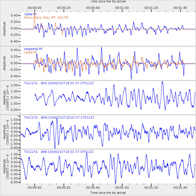
Signal To Noise
| Channel | StoN | STA | LTA |
| TA:G17A: :BHN:20090202T18:03:37.375012Z | 1.741044 | 5.5942377E-7 | 3.2131513E-7 |
| TA:G17A: :BHE:20090202T18:03:37.375012Z | 0.3340329 | 2.0853882E-7 | 6.2430627E-7 |
| TA:G17A: :BHZ:20090202T18:03:37.375012Z | 0.5370864 | 2.912148E-7 | 5.4221215E-7 |
| Arrivals |
| Ps | |
| PpPs | |
| PsPs/PpSs | |


