You are here: Home > Network List > YO16 - Yukon Observatory Stations List
> Station KOTA YGS, Kotaneelee Airstrip, YK > Earthquake Result Viewer
KOTA YGS, Kotaneelee Airstrip, YK - Earthquake Result Viewer
| Earthquake location: |
New Britain Region, P.N.G. |
| Earthquake latitude/longitude: |
-4.1/152.6 |
| Earthquake time(UTC): |
2019/05/14 (134) 12:58:26 GMT |
| Earthquake Depth: |
10 km |
| Earthquake Magnitude: |
7.5 Mww |
| Earthquake Catalog/Contributor: |
NEIC PDE/us |
|
| Network: |
YO Yukon Observatory |
| Station: |
KOTA YGS, Kotaneelee Airstrip, YK |
| Lat/Lon: |
60.13 N/124.05 W |
| Elevation: |
386 m |
|
| Distance: |
90.2 deg |
| Az: |
29.816 deg |
| Baz: |
262.243 deg |
| Ray Param: |
0.04168982 |
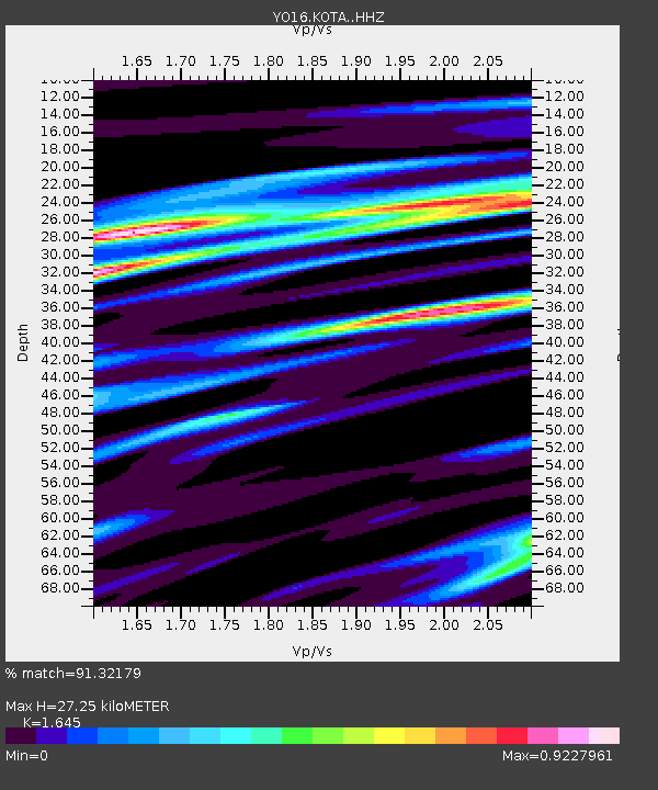
| Estimated Moho Depth: |
27.25 km |
| Estimated Crust Vp/Vs: |
1.64 |
| Assumed Crust Vp: |
6.419 km/s |
| Estimated Crust Vs: |
3.902 km/s |
| Estimated Crust Poisson's Ratio: |
0.21 |
|
| Radial Match: |
91.32179 % |
| Radial Bump: |
400 |
| Transverse Match: |
80.71872 % |
| Transverse Bump: |
400 |
| SOD ConfigId: |
18369291 |
| Insert Time: |
2019-05-28 13:05:31.726 +0000 |
| GWidth: |
2.5 |
| Max Bumps: |
400 |
| Tol: |
0.001 |
|

Signal To Noise
| Channel | StoN | STA | LTA |
| YO:KOTA: :HHZ:20190514T13:10:55.050013Z | 1.447117 | 3.837569E-7 | 2.651872E-7 |
| YO:KOTA: :HHN:20190514T13:10:55.050013Z | 1.6212274 | 3.2201527E-7 | 1.9862438E-7 |
| YO:KOTA: :HHE:20190514T13:10:55.050013Z | 1.0996246 | 2.4635173E-7 | 2.2403258E-7 |
| Arrivals |
| Ps | 2.8 SECOND |
| PpPs | 11 SECOND |
| PsPs/PpSs | 14 SECOND |


