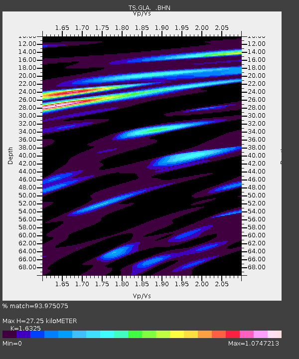
GLA Glamis, California, USA - Earthquake Result Viewer
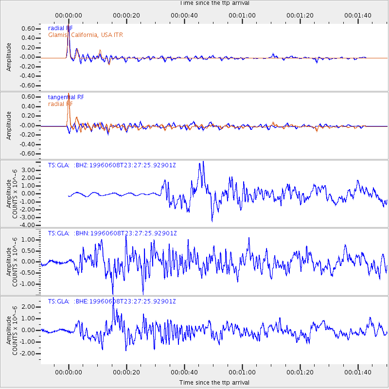
Earthquake location: Andreanof Islands, Aleutian Is.
Earthquake latitude/longitude: 51.5/-178.1
Earthquake time(UTC): 1996/06/08 (160) 23:19:15 GMT
Earthquake Depth: 33 km
Earthquake Magnitude: 5.9 MB, 6.3 MS, 6.5 UNKNOWN, 6.1 MS
Earthquake Catalog/Contributor: WHDF/NEIC
Network: TS TERRAscope (Southern California Seismic Network)
Station: GLA Glamis, California, USA
Lat/Lon: 33.05 N/114.83 W
Elevation: 627 m
Distance: 48.7 deg
Az: 86.578 deg
Baz: 312.004 deg
Ray Param: 0.069099076
Estimated Moho Depth: 27.25 km
Estimated Crust Vp/Vs: 1.63
Assumed Crust Vp: 6.155 km/s
Estimated Crust Vs: 3.77 km/s
Estimated Crust Poisson's Ratio: 0.20
Radial Match: 93.975075 %
Radial Bump: 400
Transverse Match: 76.979126 %
Transverse Bump: 400
SOD ConfigId: 6273
Insert Time: 2010-02-26 14:12:56.605 +0000
GWidth: 2.5
Max Bumps: 400
Tol: 0.001

Signal To Noise

ChannelStoNSTALTA
TS:GLA: :BHN:19960608T23:27:25.92901Z2.89077972.2323393E-77.7222744E-8
TS:GLA: :BHE:19960608T23:27:25.92901Z4.6824473.872602E-78.270466E-8
TS:GLA: :BHZ:19960608T23:27:25.92901Z5.1464297.7731806E-71.5104028E-7
Arrivals
Ps3.0 SECOND
PpPs11 SECOND
PsPs/PpSs14 SECOND