You are here: Home > Network List > CN - Canadian National Seismograph Network Stations List
> Station INK INUVIK, NT > Earthquake Result Viewer
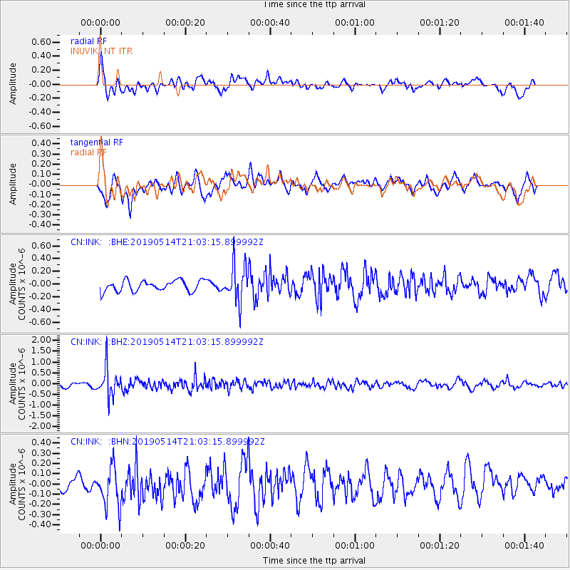
INK INUVIK, NT - Earthquake Result Viewer
*The percent match for this event was below the threshold and hence no stack was calculated.
| Earthquake location: |
Kuril Islands |
| Earthquake latitude/longitude: |
43.8/147.9 |
| Earthquake time(UTC): |
2019/05/14 (134) 20:55:26 GMT |
| Earthquake Depth: |
36 km |
| Earthquake Magnitude: |
5.2 Mww |
| Earthquake Catalog/Contributor: |
NEIC PDE/us |
|
| Network: |
CN Canadian National Seismograph Network |
| Station: |
INK INUVIK, NT |
| Lat/Lon: |
68.31 N/133.53 W |
| Elevation: |
44 m |
|
| Distance: |
46.0 deg |
| Az: |
30.417 deg |
| Baz: |
279.842 deg |
| Ray Param: |
$rayparam |
*The percent match for this event was below the threshold and hence was not used in the summary stack. |
|
| Radial Match: |
67.39694 % |
| Radial Bump: |
400 |
| Transverse Match: |
65.235016 % |
| Transverse Bump: |
400 |
| SOD ConfigId: |
18369291 |
| Insert Time: |
2019-05-28 20:58:23.468 +0000 |
| GWidth: |
2.5 |
| Max Bumps: |
400 |
| Tol: |
0.001 |
|
Signal To Noise
| Channel | StoN | STA | LTA |
| CN:INK: :BHZ:20190514T21:03:15.899992Z | 5.745674 | 6.6097004E-7 | 1.15037864E-7 |
| CN:INK: :BHN:20190514T21:03:15.899992Z | 2.309482 | 2.0690939E-7 | 8.9591246E-8 |
| CN:INK: :BHE:20190514T21:03:15.899992Z | 3.4615815 | 2.94242E-7 | 8.500219E-8 |
| Arrivals |
| Ps | |
| PpPs | |
| PsPs/PpSs | |


