You are here: Home > Network List > TA - USArray Transportable Network (new EarthScope stations) Stations List
> Station F17A Fitzpatrick Place, Clyde Park, MT, USA > Earthquake Result Viewer
F17A Fitzpatrick Place, Clyde Park, MT, USA - Earthquake Result Viewer
| Earthquake location: |
Bonin Islands, Japan Region |
| Earthquake latitude/longitude: |
26.8/142.4 |
| Earthquake time(UTC): |
2008/02/27 (058) 06:54:20 GMT |
| Earthquake Depth: |
15 km |
| Earthquake Magnitude: |
5.8 MB, 6.1 MS, 6.2 MW, 6.2 MW |
| Earthquake Catalog/Contributor: |
WHDF/NEIC |
|
| Network: |
TA USArray Transportable Network (new EarthScope stations) |
| Station: |
F17A Fitzpatrick Place, Clyde Park, MT, USA |
| Lat/Lon: |
45.91 N/110.66 W |
| Elevation: |
1545 m |
|
| Distance: |
82.0 deg |
| Az: |
42.432 deg |
| Baz: |
300.283 deg |
| Ray Param: |
0.047207415 |
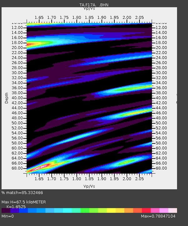
| Estimated Moho Depth: |
67.5 km |
| Estimated Crust Vp/Vs: |
1.65 |
| Assumed Crust Vp: |
6.35 km/s |
| Estimated Crust Vs: |
3.843 km/s |
| Estimated Crust Poisson's Ratio: |
0.21 |
|
| Radial Match: |
85.332466 % |
| Radial Bump: |
400 |
| Transverse Match: |
72.57284 % |
| Transverse Bump: |
400 |
| SOD ConfigId: |
2564 |
| Insert Time: |
2010-03-06 22:29:15.275 +0000 |
| GWidth: |
2.5 |
| Max Bumps: |
400 |
| Tol: |
0.001 |
|

Signal To Noise
| Channel | StoN | STA | LTA |
| TA:F17A: :BHN:20080227T07:06:08.224014Z | 0.6390885 | 1.597712E-7 | 2.4999855E-7 |
| TA:F17A: :BHE:20080227T07:06:08.224014Z | 1.2016827 | 2.0294962E-7 | 1.6888787E-7 |
| TA:F17A: :BHZ:20080227T07:06:08.224014Z | 4.0258546 | 4.1589573E-7 | 1.033062E-7 |
| Arrivals |
| Ps | 7.1 SECOND |
| PpPs | 27 SECOND |
| PsPs/PpSs | 35 SECOND |


