You are here: Home > Network List > TA - USArray Transportable Network (new EarthScope stations) Stations List
> Station F17A Fitzpatrick Place, Clyde Park, MT, USA > Earthquake Result Viewer
F17A Fitzpatrick Place, Clyde Park, MT, USA - Earthquake Result Viewer
| Earthquake location: |
Kermadec Islands Region |
| Earthquake latitude/longitude: |
-27.4/-176.3 |
| Earthquake time(UTC): |
2009/02/18 (049) 21:53:45 GMT |
| Earthquake Depth: |
25 km |
| Earthquake Magnitude: |
6.8 MB, 7.2 MS, 6.9 MW, 6.9 MW |
| Earthquake Catalog/Contributor: |
WHDF/NEIC |
|
| Network: |
TA USArray Transportable Network (new EarthScope stations) |
| Station: |
F17A Fitzpatrick Place, Clyde Park, MT, USA |
| Lat/Lon: |
45.91 N/110.66 W |
| Elevation: |
1545 m |
|
| Distance: |
94.1 deg |
| Az: |
39.636 deg |
| Baz: |
234.298 deg |
| Ray Param: |
0.04110424 |
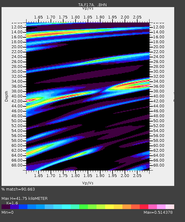
| Estimated Moho Depth: |
41.75 km |
| Estimated Crust Vp/Vs: |
1.60 |
| Assumed Crust Vp: |
6.35 km/s |
| Estimated Crust Vs: |
3.969 km/s |
| Estimated Crust Poisson's Ratio: |
0.18 |
|
| Radial Match: |
90.663 % |
| Radial Bump: |
400 |
| Transverse Match: |
91.81789 % |
| Transverse Bump: |
400 |
| SOD ConfigId: |
2658 |
| Insert Time: |
2010-03-06 22:29:19.362 +0000 |
| GWidth: |
2.5 |
| Max Bumps: |
400 |
| Tol: |
0.001 |
|

Signal To Noise
| Channel | StoN | STA | LTA |
| TA:F17A: :BHN:20090218T22:06:30.024014Z | 5.4865594 | 1.0783026E-6 | 1.9653528E-7 |
| TA:F17A: :BHE:20090218T22:06:30.024014Z | 0.8820789 | 3.050499E-7 | 3.458306E-7 |
| TA:F17A: :BHZ:20090218T22:06:30.024014Z | 1.0322031 | 4.3075846E-7 | 4.173195E-7 |
| Arrivals |
| Ps | 4.0 SECOND |
| PpPs | 17 SECOND |
| PsPs/PpSs | 21 SECOND |


