You are here: Home > Network List > TA - USArray Transportable Network (new EarthScope stations) Stations List
> Station F17A Fitzpatrick Place, Clyde Park, MT, USA > Earthquake Result Viewer
F17A Fitzpatrick Place, Clyde Park, MT, USA - Earthquake Result Viewer
| Earthquake location: |
Santa Cruz Islands |
| Earthquake latitude/longitude: |
-11.6/166.1 |
| Earthquake time(UTC): |
2009/08/10 (222) 04:06:31 GMT |
| Earthquake Depth: |
35 km |
| Earthquake Magnitude: |
5.8 MB, 6.3 MS, 6.6 MW, 6.6 MW |
| Earthquake Catalog/Contributor: |
WHDF/NEIC |
|
| Network: |
TA USArray Transportable Network (new EarthScope stations) |
| Station: |
F17A Fitzpatrick Place, Clyde Park, MT, USA |
| Lat/Lon: |
45.91 N/110.66 W |
| Elevation: |
1545 m |
|
| Distance: |
93.6 deg |
| Az: |
44.01 deg |
| Baz: |
257.144 deg |
| Ray Param: |
0.041217122 |
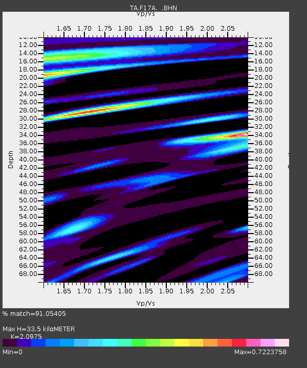
| Estimated Moho Depth: |
33.5 km |
| Estimated Crust Vp/Vs: |
2.10 |
| Assumed Crust Vp: |
6.35 km/s |
| Estimated Crust Vs: |
3.027 km/s |
| Estimated Crust Poisson's Ratio: |
0.35 |
|
| Radial Match: |
91.05405 % |
| Radial Bump: |
400 |
| Transverse Match: |
75.81049 % |
| Transverse Bump: |
400 |
| SOD ConfigId: |
2622 |
| Insert Time: |
2010-03-06 22:29:23.212 +0000 |
| GWidth: |
2.5 |
| Max Bumps: |
400 |
| Tol: |
0.001 |
|

Signal To Noise
| Channel | StoN | STA | LTA |
| TA:F17A: :BHN:20090810T04:19:12.200012Z | 5.602841 | 4.9439313E-7 | 8.823972E-8 |
| TA:F17A: :BHE:20090810T04:19:12.200012Z | 0.97027355 | 5.9131292E-8 | 6.094291E-8 |
| TA:F17A: :BHZ:20090810T04:19:12.200012Z | 2.8480055 | 1.8013652E-7 | 6.325006E-8 |
| Arrivals |
| Ps | 5.9 SECOND |
| PpPs | 16 SECOND |
| PsPs/PpSs | 22 SECOND |


