You are here: Home > Network List > TA - USArray Transportable Network (new EarthScope stations) Stations List
> Station F17A Fitzpatrick Place, Clyde Park, MT, USA > Earthquake Result Viewer
F17A Fitzpatrick Place, Clyde Park, MT, USA - Earthquake Result Viewer
| Earthquake location: |
Norwegian Sea |
| Earthquake latitude/longitude: |
72.2/0.9 |
| Earthquake time(UTC): |
2009/08/20 (232) 06:35:04 GMT |
| Earthquake Depth: |
6.0 km |
| Earthquake Magnitude: |
5.9 MB, 5.7 MS, 6.0 MW, 6.0 MW |
| Earthquake Catalog/Contributor: |
WHDF/NEIC |
|
| Network: |
TA USArray Transportable Network (new EarthScope stations) |
| Station: |
F17A Fitzpatrick Place, Clyde Park, MT, USA |
| Lat/Lon: |
45.91 N/110.66 W |
| Elevation: |
1545 m |
|
| Distance: |
53.0 deg |
| Az: |
305.6 deg |
| Baz: |
20.987 deg |
| Ray Param: |
0.066416845 |
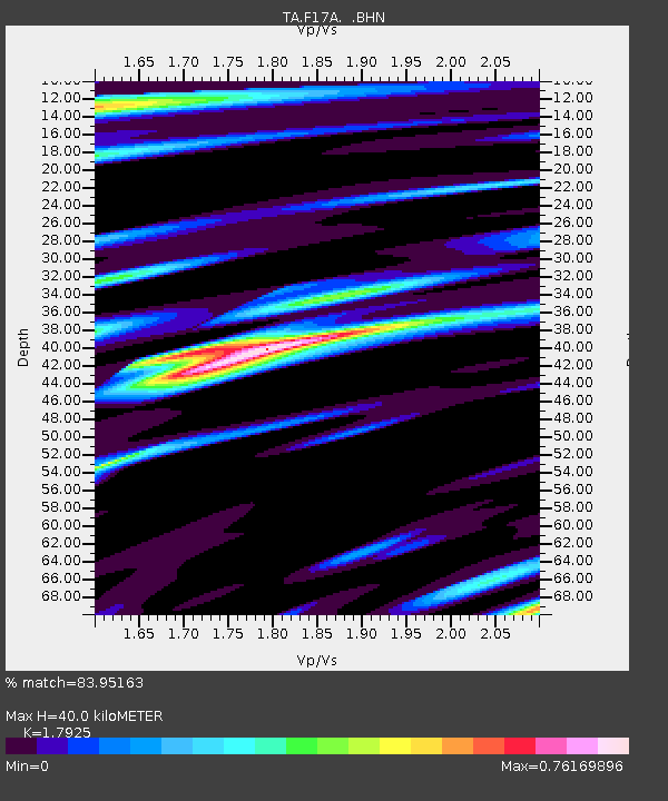
| Estimated Moho Depth: |
40.0 km |
| Estimated Crust Vp/Vs: |
1.79 |
| Assumed Crust Vp: |
6.35 km/s |
| Estimated Crust Vs: |
3.543 km/s |
| Estimated Crust Poisson's Ratio: |
0.27 |
|
| Radial Match: |
83.95163 % |
| Radial Bump: |
400 |
| Transverse Match: |
79.73343 % |
| Transverse Bump: |
400 |
| SOD ConfigId: |
2622 |
| Insert Time: |
2010-03-06 22:29:30.704 +0000 |
| GWidth: |
2.5 |
| Max Bumps: |
400 |
| Tol: |
0.001 |
|

Signal To Noise
| Channel | StoN | STA | LTA |
| TA:F17A: :BHN:20090820T06:43:50.724006Z | 8.697229 | 7.6240246E-7 | 8.766039E-8 |
| TA:F17A: :BHE:20090820T06:43:50.724006Z | 3.7520049 | 3.0720992E-7 | 8.187887E-8 |
| TA:F17A: :BHZ:20090820T06:43:50.724006Z | 1.2461646 | 1.286979E-7 | 1.0327521E-7 |
| Arrivals |
| Ps | 5.3 SECOND |
| PpPs | 17 SECOND |
| PsPs/PpSs | 22 SECOND |


