You are here: Home > Network List > IU - Global Seismograph Network (GSN - IRIS/USGS) Stations List
> Station RSSD Black Hills, South Dakota, USA > Earthquake Result Viewer
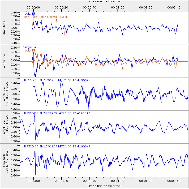
RSSD Black Hills, South Dakota, USA - Earthquake Result Viewer
*The percent match for this event was below the threshold and hence no stack was calculated.
| Earthquake location: |
Kuril Islands |
| Earthquake latitude/longitude: |
43.8/147.9 |
| Earthquake time(UTC): |
2019/05/14 (134) 20:55:26 GMT |
| Earthquake Depth: |
36 km |
| Earthquake Magnitude: |
5.2 Mww |
| Earthquake Catalog/Contributor: |
NEIC PDE/us |
|
| Network: |
IU Global Seismograph Network (GSN - IRIS/USGS) |
| Station: |
RSSD Black Hills, South Dakota, USA |
| Lat/Lon: |
44.12 N/104.04 W |
| Elevation: |
2090 m |
|
| Distance: |
71.5 deg |
| Az: |
46.247 deg |
| Baz: |
313.475 deg |
| Ray Param: |
$rayparam |
*The percent match for this event was below the threshold and hence was not used in the summary stack. |
|
| Radial Match: |
46.031425 % |
| Radial Bump: |
400 |
| Transverse Match: |
60.00994 % |
| Transverse Bump: |
400 |
| SOD ConfigId: |
18369291 |
| Insert Time: |
2019-05-28 20:59:56.655 +0000 |
| GWidth: |
2.5 |
| Max Bumps: |
400 |
| Tol: |
0.001 |
|
Signal To Noise
| Channel | StoN | STA | LTA |
| IU:RSSD:00:BHZ:20190514T21:06:12.419004Z | 1.5519205 | 4.4171878E-7 | 2.846272E-7 |
| IU:RSSD:00:BH1:20190514T21:06:12.419004Z | 1.9422743 | 2.3953464E-7 | 1.2332688E-7 |
| IU:RSSD:00:BH2:20190514T21:06:12.419004Z | 0.6887873 | 1.9103072E-7 | 2.7734356E-7 |
| Arrivals |
| Ps | |
| PpPs | |
| PsPs/PpSs | |


