You are here: Home > Network List > TA - USArray Transportable Network (new EarthScope stations) Stations List
> Station F17A Fitzpatrick Place, Clyde Park, MT, USA > Earthquake Result Viewer
F17A Fitzpatrick Place, Clyde Park, MT, USA - Earthquake Result Viewer
| Earthquake location: |
Hokkaido, Japan Region |
| Earthquake latitude/longitude: |
41.8/143.4 |
| Earthquake time(UTC): |
2009/06/05 (156) 03:30:33 GMT |
| Earthquake Depth: |
29 km |
| Earthquake Magnitude: |
6.0 MB, 6.3 MS, 6.4 MW, 6.4 MW |
| Earthquake Catalog/Contributor: |
WHDF/NEIC |
|
| Network: |
TA USArray Transportable Network (new EarthScope stations) |
| Station: |
F17A Fitzpatrick Place, Clyde Park, MT, USA |
| Lat/Lon: |
45.91 N/110.66 W |
| Elevation: |
1545 m |
|
| Distance: |
70.6 deg |
| Az: |
45.406 deg |
| Baz: |
310.338 deg |
| Ray Param: |
0.05485406 |
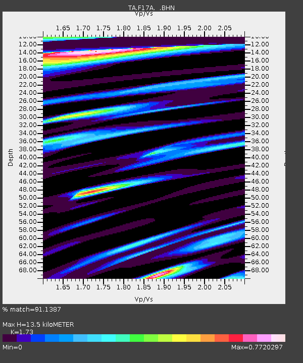
| Estimated Moho Depth: |
13.5 km |
| Estimated Crust Vp/Vs: |
1.73 |
| Assumed Crust Vp: |
6.35 km/s |
| Estimated Crust Vs: |
3.671 km/s |
| Estimated Crust Poisson's Ratio: |
0.25 |
|
| Radial Match: |
91.1387 % |
| Radial Bump: |
400 |
| Transverse Match: |
85.58458 % |
| Transverse Bump: |
400 |
| SOD ConfigId: |
2648 |
| Insert Time: |
2010-03-06 22:29:35.162 +0000 |
| GWidth: |
2.5 |
| Max Bumps: |
400 |
| Tol: |
0.001 |
|

Signal To Noise
| Channel | StoN | STA | LTA |
| TA:F17A: :BHN:20090605T03:41:14.375002Z | 6.622701 | 4.6806488E-7 | 7.0675824E-8 |
| TA:F17A: :BHE:20090605T03:41:14.375002Z | 2.2752633 | 1.0399376E-7 | 4.5706255E-8 |
| TA:F17A: :BHZ:20090605T03:41:14.375002Z | 3.3804212 | 1.8664018E-7 | 5.5212112E-8 |
| Arrivals |
| Ps | 1.6 SECOND |
| PpPs | 5.6 SECOND |
| PsPs/PpSs | 7.2 SECOND |


