You are here: Home > Network List > TA - USArray Transportable Network (new EarthScope stations) Stations List
> Station F17A Fitzpatrick Place, Clyde Park, MT, USA > Earthquake Result Viewer
F17A Fitzpatrick Place, Clyde Park, MT, USA - Earthquake Result Viewer
| Earthquake location: |
Northern Mid-Atlantic Ridge |
| Earthquake latitude/longitude: |
23.9/-46.1 |
| Earthquake time(UTC): |
2009/06/06 (157) 20:33:28 GMT |
| Earthquake Depth: |
14 km |
| Earthquake Magnitude: |
6.0 MB, 5.7 MS, 6.0 MW, 6.0 MW |
| Earthquake Catalog/Contributor: |
WHDF/NEIC |
|
| Network: |
TA USArray Transportable Network (new EarthScope stations) |
| Station: |
F17A Fitzpatrick Place, Clyde Park, MT, USA |
| Lat/Lon: |
45.91 N/110.66 W |
| Elevation: |
1545 m |
|
| Distance: |
55.8 deg |
| Az: |
310.298 deg |
| Baz: |
90.047 deg |
| Ray Param: |
0.06457348 |
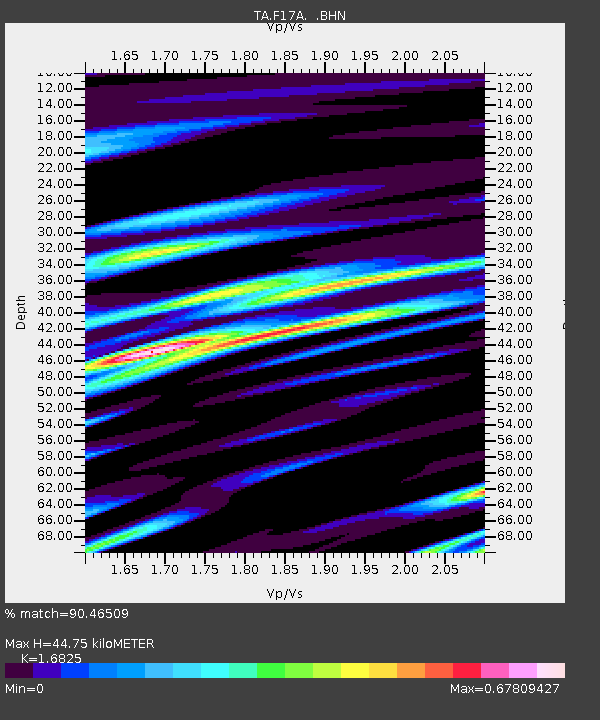
| Estimated Moho Depth: |
44.75 km |
| Estimated Crust Vp/Vs: |
1.68 |
| Assumed Crust Vp: |
6.35 km/s |
| Estimated Crust Vs: |
3.774 km/s |
| Estimated Crust Poisson's Ratio: |
0.23 |
|
| Radial Match: |
90.46509 % |
| Radial Bump: |
400 |
| Transverse Match: |
87.09215 % |
| Transverse Bump: |
400 |
| SOD ConfigId: |
2648 |
| Insert Time: |
2010-03-06 22:29:42.088 +0000 |
| GWidth: |
2.5 |
| Max Bumps: |
400 |
| Tol: |
0.001 |
|

Signal To Noise
| Channel | StoN | STA | LTA |
| TA:F17A: :BHN:20090606T20:42:34.025007Z | 10.733229 | 8.132052E-7 | 7.576519E-8 |
| TA:F17A: :BHE:20090606T20:42:34.025007Z | 1.8493097 | 1.16704896E-7 | 6.310728E-8 |
| TA:F17A: :BHZ:20090606T20:42:34.025007Z | 4.612798 | 2.9911715E-7 | 6.4845054E-8 |
| Arrivals |
| Ps | 5.1 SECOND |
| PpPs | 18 SECOND |
| PsPs/PpSs | 23 SECOND |


