You are here: Home > Network List > TS - TERRAscope (Southern California Seismic Network) Stations List
> Station GLA Glamis, California, USA > Earthquake Result Viewer
GLA Glamis, California, USA - Earthquake Result Viewer
| Earthquake location: |
Off Coast Of Northern Peru |
| Earthquake latitude/longitude: |
-9.6/-79.6 |
| Earthquake time(UTC): |
1996/02/21 (052) 12:51:04 GMT |
| Earthquake Depth: |
33 km |
| Earthquake Magnitude: |
5.8 MB, 6.6 MS, 7.5 UNKNOWN, 7.3 MW |
| Earthquake Catalog/Contributor: |
WHDF/NEIC |
|
| Network: |
TS TERRAscope (Southern California Seismic Network) |
| Station: |
GLA Glamis, California, USA |
| Lat/Lon: |
33.05 N/114.83 W |
| Elevation: |
627 m |
|
| Distance: |
54.1 deg |
| Az: |
323.246 deg |
| Baz: |
135.363 deg |
| Ray Param: |
0.06559056 |
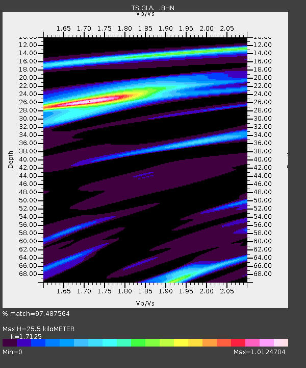
| Estimated Moho Depth: |
25.5 km |
| Estimated Crust Vp/Vs: |
1.71 |
| Assumed Crust Vp: |
6.155 km/s |
| Estimated Crust Vs: |
3.594 km/s |
| Estimated Crust Poisson's Ratio: |
0.24 |
|
| Radial Match: |
97.487564 % |
| Radial Bump: |
379 |
| Transverse Match: |
80.49059 % |
| Transverse Bump: |
400 |
| SOD ConfigId: |
6273 |
| Insert Time: |
2010-02-26 14:13:02.473 +0000 |
| GWidth: |
2.5 |
| Max Bumps: |
400 |
| Tol: |
0.001 |
|

Signal To Noise
| Channel | StoN | STA | LTA |
| TS:GLA: :BHN:19960221T12:59:55.375012Z | 0.7482129 | 2.2393341E-7 | 2.9929103E-7 |
| TS:GLA: :BHE:19960221T12:59:55.375012Z | 1.247275 | 3.324802E-7 | 2.6656528E-7 |
| TS:GLA: :BHZ:19960221T12:59:55.375012Z | 1.3360112 | 5.3995484E-7 | 4.0415443E-7 |
| Arrivals |
| Ps | 3.1 SECOND |
| PpPs | 11 SECOND |
| PsPs/PpSs | 14 SECOND |


