You are here: Home > Network List > IW - Intermountain West Stations List
> Station MOOW Moose Ponds, Wyoming, USA > Earthquake Result Viewer
MOOW Moose Ponds, Wyoming, USA - Earthquake Result Viewer
| Earthquake location: |
Central Italy |
| Earthquake latitude/longitude: |
42.9/13.1 |
| Earthquake time(UTC): |
2016/10/30 (304) 06:40:19 GMT |
| Earthquake Depth: |
10 km |
| Earthquake Magnitude: |
6.6 MWW, 6.6 MWR |
| Earthquake Catalog/Contributor: |
NEIC PDE/NEIC COMCAT |
|
| Network: |
IW Intermountain West |
| Station: |
MOOW Moose Ponds, Wyoming, USA |
| Lat/Lon: |
43.75 N/110.74 W |
| Elevation: |
2128 m |
|
| Distance: |
80.2 deg |
| Az: |
322.346 deg |
| Baz: |
38.307 deg |
| Ray Param: |
0.048441097 |
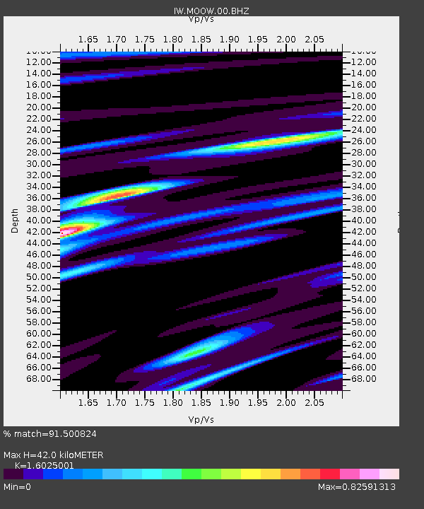
| Estimated Moho Depth: |
42.0 km |
| Estimated Crust Vp/Vs: |
1.60 |
| Assumed Crust Vp: |
6.207 km/s |
| Estimated Crust Vs: |
3.873 km/s |
| Estimated Crust Poisson's Ratio: |
0.18 |
|
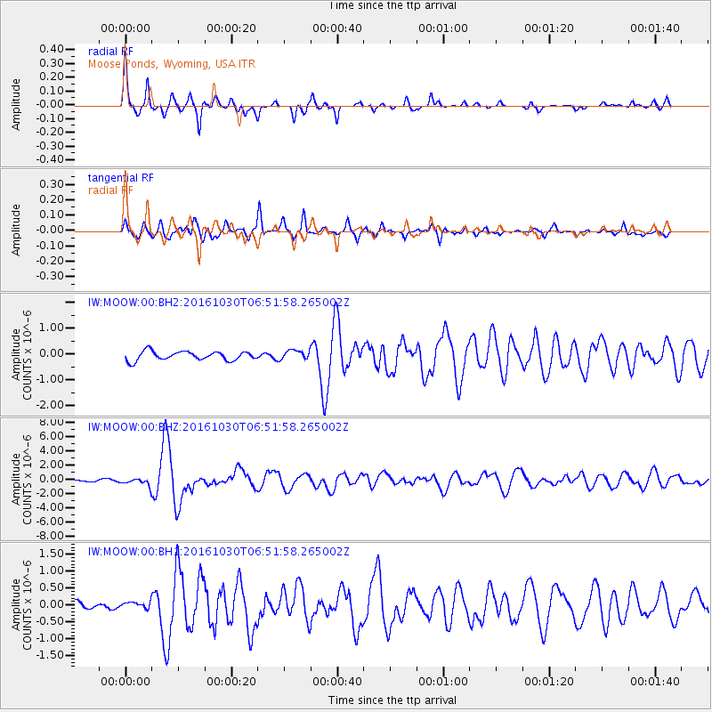
| Radial Match: |
91.500824 % |
| Radial Bump: |
255 |
| Transverse Match: |
87.32215 % |
| Transverse Bump: |
400 |
| SOD ConfigId: |
1815711 |
| Insert Time: |
2016-11-13 06:44:17.340 +0000 |
| GWidth: |
2.5 |
| Max Bumps: |
400 |
| Tol: |
0.001 |
|
Signal To Noise
| Channel | StoN | STA | LTA |
| IW:MOOW:00:BHZ:20161030T06:51:58.265002Z | 5.06241 | 5.0082974E-7 | 9.8931096E-8 |
| IW:MOOW:00:BH1:20161030T06:51:58.265002Z | 0.522325 | 9.950246E-8 | 1.9049914E-7 |
| IW:MOOW:00:BH2:20161030T06:51:58.265002Z | 1.0505797 | 1.8083563E-7 | 1.7212939E-7 |
| Arrivals |
| Ps | 4.2 SECOND |
| PpPs | 17 SECOND |
| PsPs/PpSs | 21 SECOND |


