You are here: Home > Network List > TA - USArray Transportable Network (new EarthScope stations) Stations List
> Station D23K Nanushuk River, AK USA > Earthquake Result Viewer
D23K Nanushuk River, AK USA - Earthquake Result Viewer
*The percent match for this event was below the threshold and hence no stack was calculated.
| Earthquake location: |
Kuril Islands |
| Earthquake latitude/longitude: |
43.8/147.9 |
| Earthquake time(UTC): |
2019/05/14 (134) 20:55:26 GMT |
| Earthquake Depth: |
36 km |
| Earthquake Magnitude: |
5.2 Mww |
| Earthquake Catalog/Contributor: |
NEIC PDE/us |
|
| Network: |
TA USArray Transportable Network (new EarthScope stations) |
| Station: |
D23K Nanushuk River, AK USA |
| Lat/Lon: |
68.97 N/150.68 W |
| Elevation: |
406 m |
|
| Distance: |
39.7 deg |
| Az: |
29.711 deg |
| Baz: |
263.346 deg |
| Ray Param: |
$rayparam |
*The percent match for this event was below the threshold and hence was not used in the summary stack. |
|
| Radial Match: |
75.493996 % |
| Radial Bump: |
400 |
| Transverse Match: |
69.217224 % |
| Transverse Bump: |
400 |
| SOD ConfigId: |
18369291 |
| Insert Time: |
2019-05-28 21:03:13.335 +0000 |
| GWidth: |
2.5 |
| Max Bumps: |
400 |
| Tol: |
0.001 |
|
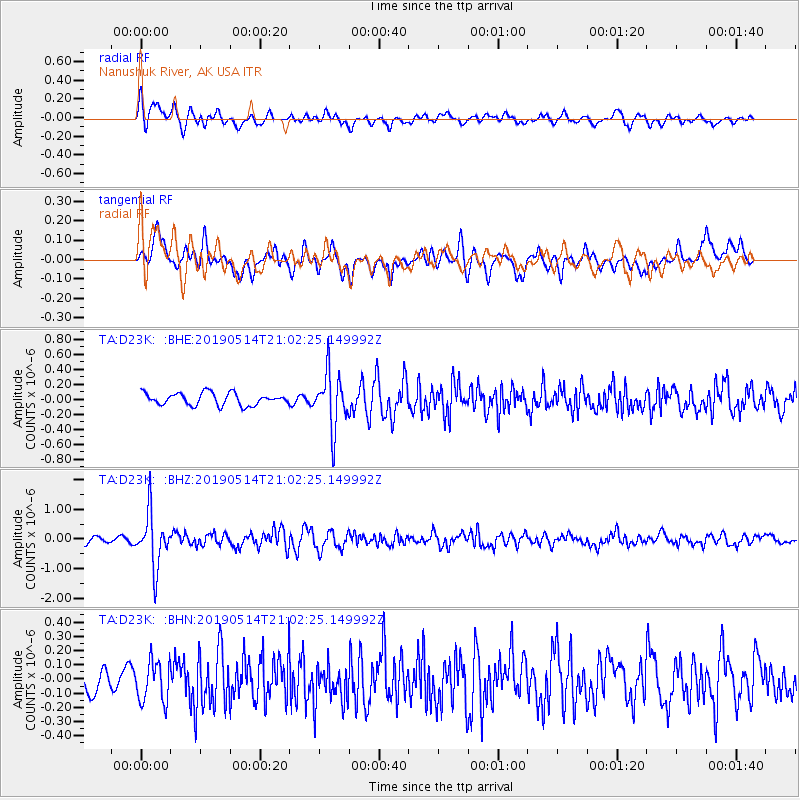
Signal To Noise
| Channel | StoN | STA | LTA |
| TA:D23K: :BHZ:20190514T21:02:25.149992Z | 8.252211 | 8.995432E-7 | 1.0900633E-7 |
| TA:D23K: :BHN:20190514T21:02:25.149992Z | 2.2684853 | 1.4366164E-7 | 6.3329324E-8 |
| TA:D23K: :BHE:20190514T21:02:25.149992Z | 4.5490956 | 3.6745723E-7 | 8.0775884E-8 |
| Arrivals |
| Ps | |
| PpPs | |
| PsPs/PpSs | |


