You are here: Home > Network List > TA - USArray Transportable Network (new EarthScope stations) Stations List
> Station E20K Nigu River, AK, USA > Earthquake Result Viewer
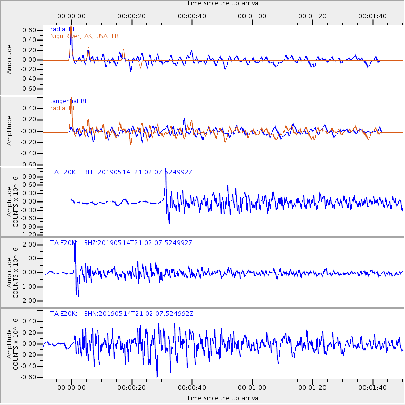
E20K Nigu River, AK, USA - Earthquake Result Viewer
*The percent match for this event was below the threshold and hence no stack was calculated.
| Earthquake location: |
Kuril Islands |
| Earthquake latitude/longitude: |
43.8/147.9 |
| Earthquake time(UTC): |
2019/05/14 (134) 20:55:26 GMT |
| Earthquake Depth: |
36 km |
| Earthquake Magnitude: |
5.2 Mww |
| Earthquake Catalog/Contributor: |
NEIC PDE/us |
|
| Network: |
TA USArray Transportable Network (new EarthScope stations) |
| Station: |
E20K Nigu River, AK, USA |
| Lat/Lon: |
68.26 N/156.19 W |
| Elevation: |
866 m |
|
| Distance: |
37.6 deg |
| Az: |
30.33 deg |
| Baz: |
258.705 deg |
| Ray Param: |
$rayparam |
*The percent match for this event was below the threshold and hence was not used in the summary stack. |
|
| Radial Match: |
78.11989 % |
| Radial Bump: |
400 |
| Transverse Match: |
74.4896 % |
| Transverse Bump: |
400 |
| SOD ConfigId: |
18369291 |
| Insert Time: |
2019-05-28 21:03:18.113 +0000 |
| GWidth: |
2.5 |
| Max Bumps: |
400 |
| Tol: |
0.001 |
|
Signal To Noise
| Channel | StoN | STA | LTA |
| TA:E20K: :BHZ:20190514T21:02:07.524992Z | 11.687984 | 7.609594E-7 | 6.510613E-8 |
| TA:E20K: :BHN:20190514T21:02:07.524992Z | 2.1609147 | 1.217285E-7 | 5.6331935E-8 |
| TA:E20K: :BHE:20190514T21:02:07.524992Z | 8.674991 | 3.7070615E-7 | 4.2732744E-8 |
| Arrivals |
| Ps | |
| PpPs | |
| PsPs/PpSs | |


