You are here: Home > Network List > TA - USArray Transportable Network (new EarthScope stations) Stations List
> Station G26K Porcupine River, AK, USA > Earthquake Result Viewer
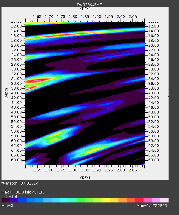
G26K Porcupine River, AK, USA - Earthquake Result Viewer
| Earthquake location: |
Kuril Islands |
| Earthquake latitude/longitude: |
43.8/147.9 |
| Earthquake time(UTC): |
2019/05/14 (134) 20:55:26 GMT |
| Earthquake Depth: |
36 km |
| Earthquake Magnitude: |
5.2 Mww |
| Earthquake Catalog/Contributor: |
NEIC PDE/us |
|
| Network: |
TA USArray Transportable Network (new EarthScope stations) |
| Station: |
G26K Porcupine River, AK, USA |
| Lat/Lon: |
66.95 N/143.78 W |
| Elevation: |
180 m |
|
| Distance: |
42.3 deg |
| Az: |
32.945 deg |
| Baz: |
272.175 deg |
| Ray Param: |
0.07320094 |
| Estimated Moho Depth: |
38.0 km |
| Estimated Crust Vp/Vs: |
1.60 |
| Assumed Crust Vp: |
6.577 km/s |
| Estimated Crust Vs: |
4.11 km/s |
| Estimated Crust Poisson's Ratio: |
0.18 |
|
| Radial Match: |
87.81514 % |
| Radial Bump: |
400 |
| Transverse Match: |
84.41711 % |
| Transverse Bump: |
400 |
| SOD ConfigId: |
18369291 |
| Insert Time: |
2019-05-28 21:03:38.234 +0000 |
| GWidth: |
2.5 |
| Max Bumps: |
400 |
| Tol: |
0.001 |
|

Signal To Noise
| Channel | StoN | STA | LTA |
| TA:G26K: :BHZ:20190514T21:02:45.850004Z | 9.506396 | 1.1826467E-6 | 1.2440536E-7 |
| TA:G26K: :BHN:20190514T21:02:45.850004Z | 4.5945168 | 6.2232135E-7 | 1.3544872E-7 |
| TA:G26K: :BHE:20190514T21:02:45.850004Z | 7.8988104 | 7.7221193E-7 | 9.776306E-8 |
| Arrivals |
| Ps | 3.8 SECOND |
| PpPs | 14 SECOND |
| PsPs/PpSs | 18 SECOND |


