You are here: Home > Network List > TA - USArray Transportable Network (new EarthScope stations) Stations List
> Station L15K Ungalak Mountain, AK, USA > Earthquake Result Viewer
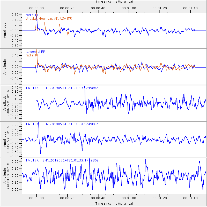
L15K Ungalak Mountain, AK, USA - Earthquake Result Viewer
*The percent match for this event was below the threshold and hence no stack was calculated.
| Earthquake location: |
Kuril Islands |
| Earthquake latitude/longitude: |
43.8/147.9 |
| Earthquake time(UTC): |
2019/05/14 (134) 20:55:26 GMT |
| Earthquake Depth: |
36 km |
| Earthquake Magnitude: |
5.2 Mww |
| Earthquake Catalog/Contributor: |
NEIC PDE/us |
|
| Network: |
TA USArray Transportable Network (new EarthScope stations) |
| Station: |
L15K Ungalak Mountain, AK, USA |
| Lat/Lon: |
61.68 N/161.49 W |
| Elevation: |
219 m |
|
| Distance: |
34.3 deg |
| Az: |
40.791 deg |
| Baz: |
262.378 deg |
| Ray Param: |
$rayparam |
*The percent match for this event was below the threshold and hence was not used in the summary stack. |
|
| Radial Match: |
61.018322 % |
| Radial Bump: |
400 |
| Transverse Match: |
57.638283 % |
| Transverse Bump: |
400 |
| SOD ConfigId: |
18369291 |
| Insert Time: |
2019-05-28 21:04:04.524 +0000 |
| GWidth: |
2.5 |
| Max Bumps: |
400 |
| Tol: |
0.001 |
|
Signal To Noise
| Channel | StoN | STA | LTA |
| TA:L15K: :BHZ:20190514T21:01:39.174986Z | 5.103499 | 3.163215E-7 | 6.1981304E-8 |
| TA:L15K: :BHN:20190514T21:01:39.174986Z | 1.7128872 | 7.6331354E-8 | 4.4562977E-8 |
| TA:L15K: :BHE:20190514T21:01:39.174986Z | 2.1811452 | 1.5692122E-7 | 7.194442E-8 |
| Arrivals |
| Ps | |
| PpPs | |
| PsPs/PpSs | |


