You are here: Home > Network List > TS - TERRAscope (Southern California Seismic Network) Stations List
> Station GLA Glamis, California, USA > Earthquake Result Viewer
GLA Glamis, California, USA - Earthquake Result Viewer

| Earthquake location: |
Near Coast Of Nicaragua |
| Earthquake latitude/longitude: |
11.7/-86.9 |
| Earthquake time(UTC): |
1996/03/03 (063) 14:55:11 GMT |
| Earthquake Depth: |
33 km |
| Earthquake Magnitude: |
5.7 MB, 6.5 MS, 6.8 UNKNOWN, 6.4 MS |
| Earthquake Catalog/Contributor: |
WHDF/NEIC |
|
| Network: |
TS TERRAscope (Southern California Seismic Network) |
| Station: |
GLA Glamis, California, USA |
| Lat/Lon: |
33.05 N/114.83 W |
| Elevation: |
627 m |
|
| Distance: |
33.3 deg |
| Az: |
314.186 deg |
| Baz: |
123.233 deg |
| Ray Param: |
0.07820845 |
| Estimated Moho Depth: |
26.5 km |
| Estimated Crust Vp/Vs: |
1.66 |
| Assumed Crust Vp: |
6.155 km/s |
| Estimated Crust Vs: |
3.713 km/s |
| Estimated Crust Poisson's Ratio: |
0.21 |
|
| Radial Match: |
93.3093 % |
| Radial Bump: |
306 |
| Transverse Match: |
78.50466 % |
| Transverse Bump: |
400 |
| SOD ConfigId: |
6273 |
| Insert Time: |
2010-02-26 14:13:04.106 +0000 |
| GWidth: |
2.5 |
| Max Bumps: |
400 |
| Tol: |
0.001 |
|
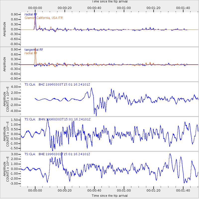
Signal To Noise
| Channel | StoN | STA | LTA |
| TS:GLA: :BHN:19960303T15:01:16.24101Z | 1.3848487 | 3.9754448E-7 | 2.8706708E-7 |
| TS:GLA: :BHE:19960303T15:01:16.24101Z | 2.3068228 | 4.4281032E-7 | 1.919568E-7 |
| TS:GLA: :BHZ:19960303T15:01:16.24101Z | 3.60238 | 9.539045E-7 | 2.6479842E-7 |
| Arrivals |
| Ps | 3.1 SECOND |
| PpPs | 11 SECOND |
| PsPs/PpSs | 14 SECOND |


