You are here: Home > Network List > TA - USArray Transportable Network (new EarthScope stations) Stations List
> Station O17K Koliganek, Bristol Bay, AK, USA > Earthquake Result Viewer
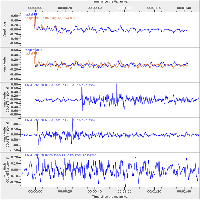
O17K Koliganek, Bristol Bay, AK, USA - Earthquake Result Viewer
*The percent match for this event was below the threshold and hence no stack was calculated.
| Earthquake location: |
Kuril Islands |
| Earthquake latitude/longitude: |
43.8/147.9 |
| Earthquake time(UTC): |
2019/05/14 (134) 20:55:26 GMT |
| Earthquake Depth: |
36 km |
| Earthquake Magnitude: |
5.2 Mww |
| Earthquake Catalog/Contributor: |
NEIC PDE/us |
|
| Network: |
TA USArray Transportable Network (new EarthScope stations) |
| Station: |
O17K Koliganek, Bristol Bay, AK, USA |
| Lat/Lon: |
59.77 N/157.09 W |
| Elevation: |
156 m |
|
| Distance: |
36.3 deg |
| Az: |
44.362 deg |
| Baz: |
269.119 deg |
| Ray Param: |
$rayparam |
*The percent match for this event was below the threshold and hence was not used in the summary stack. |
|
| Radial Match: |
77.865685 % |
| Radial Bump: |
400 |
| Transverse Match: |
52.90894 % |
| Transverse Bump: |
400 |
| SOD ConfigId: |
18369291 |
| Insert Time: |
2019-05-28 21:04:24.013 +0000 |
| GWidth: |
2.5 |
| Max Bumps: |
400 |
| Tol: |
0.001 |
|
Signal To Noise
| Channel | StoN | STA | LTA |
| TA:O17K: :BHZ:20190514T21:01:56.424986Z | 6.2489815 | 3.9816697E-7 | 6.37171E-8 |
| TA:O17K: :BHN:20190514T21:01:56.424986Z | 2.0854528 | 1.2199736E-7 | 5.8499214E-8 |
| TA:O17K: :BHE:20190514T21:01:56.424986Z | 4.2754717 | 2.4270554E-7 | 5.6766964E-8 |
| Arrivals |
| Ps | |
| PpPs | |
| PsPs/PpSs | |


