You are here: Home > Network List > TA - USArray Transportable Network (new EarthScope stations) Stations List
> Station R33M Jennings River, BC, CAN > Earthquake Result Viewer
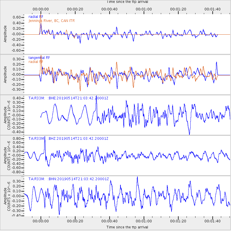
R33M Jennings River, BC, CAN - Earthquake Result Viewer
*The percent match for this event was below the threshold and hence no stack was calculated.
| Earthquake location: |
Kuril Islands |
| Earthquake latitude/longitude: |
43.8/147.9 |
| Earthquake time(UTC): |
2019/05/14 (134) 20:55:26 GMT |
| Earthquake Depth: |
36 km |
| Earthquake Magnitude: |
5.2 Mww |
| Earthquake Catalog/Contributor: |
NEIC PDE/us |
|
| Network: |
TA USArray Transportable Network (new EarthScope stations) |
| Station: |
R33M Jennings River, BC, CAN |
| Lat/Lon: |
59.39 N/130.97 W |
| Elevation: |
1437 m |
|
| Distance: |
49.4 deg |
| Az: |
41.721 deg |
| Baz: |
289.764 deg |
| Ray Param: |
$rayparam |
*The percent match for this event was below the threshold and hence was not used in the summary stack. |
|
| Radial Match: |
68.6717 % |
| Radial Bump: |
400 |
| Transverse Match: |
61.591625 % |
| Transverse Bump: |
400 |
| SOD ConfigId: |
18369291 |
| Insert Time: |
2019-05-28 21:04:37.979 +0000 |
| GWidth: |
2.5 |
| Max Bumps: |
400 |
| Tol: |
0.001 |
|
Signal To Noise
| Channel | StoN | STA | LTA |
| TA:R33M: :BHZ:20190514T21:03:42.20001Z | 2.496118 | 3.2317658E-7 | 1.2947167E-7 |
| TA:R33M: :BHN:20190514T21:03:42.20001Z | 0.9600829 | 1.03687995E-7 | 1.07999E-7 |
| TA:R33M: :BHE:20190514T21:03:42.20001Z | 1.3450727 | 1.6855432E-7 | 1.2531243E-7 |
| Arrivals |
| Ps | |
| PpPs | |
| PsPs/PpSs | |


