You are here: Home > Network List > TX - Texas Seismological Network Stations List
> Station WTFS Witchita Falls > Earthquake Result Viewer
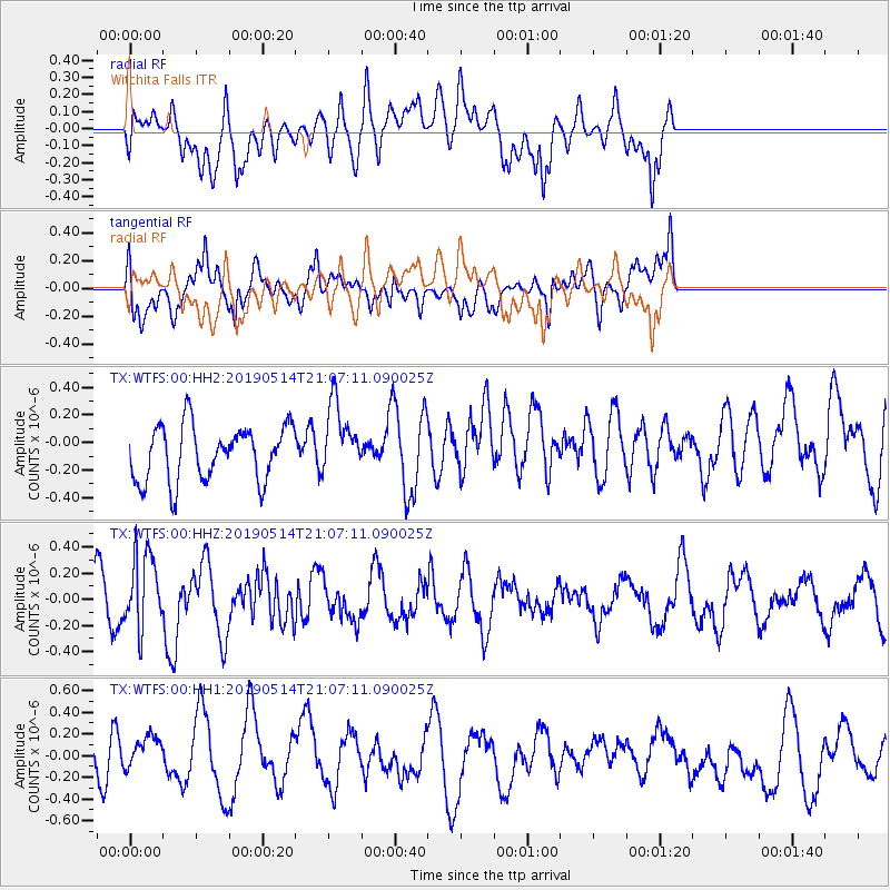
WTFS Witchita Falls - Earthquake Result Viewer
*The percent match for this event was below the threshold and hence no stack was calculated.
| Earthquake location: |
Kuril Islands |
| Earthquake latitude/longitude: |
43.8/147.9 |
| Earthquake time(UTC): |
2019/05/14 (134) 20:55:26 GMT |
| Earthquake Depth: |
36 km |
| Earthquake Magnitude: |
5.2 Mww |
| Earthquake Catalog/Contributor: |
NEIC PDE/us |
|
| Network: |
TX Texas Seismological Network |
| Station: |
WTFS Witchita Falls |
| Lat/Lon: |
33.77 N/98.46 W |
| Elevation: |
277 m |
|
| Distance: |
81.9 deg |
| Az: |
50.454 deg |
| Baz: |
317.952 deg |
| Ray Param: |
$rayparam |
*The percent match for this event was below the threshold and hence was not used in the summary stack. |
|
| Radial Match: |
53.9767 % |
| Radial Bump: |
400 |
| Transverse Match: |
66.76332 % |
| Transverse Bump: |
400 |
| SOD ConfigId: |
18369291 |
| Insert Time: |
2019-05-28 21:05:10.995 +0000 |
| GWidth: |
2.5 |
| Max Bumps: |
400 |
| Tol: |
0.001 |
|
Signal To Noise
| Channel | StoN | STA | LTA |
| TX:WTFS:00:HHZ:20190514T21:07:11.090025Z | 2.9055326 | 2.86278E-7 | 9.852858E-8 |
| TX:WTFS:00:HH1:20190514T21:07:11.090025Z | 0.82342297 | 1.6255107E-7 | 1.9740897E-7 |
| TX:WTFS:00:HH2:20190514T21:07:11.090025Z | 1.3110609 | 2.614126E-7 | 1.9939012E-7 |
| Arrivals |
| Ps | |
| PpPs | |
| PsPs/PpSs | |


