You are here: Home > Network List > TS - TERRAscope (Southern California Seismic Network) Stations List
> Station GLA Glamis, California, USA > Earthquake Result Viewer
GLA Glamis, California, USA - Earthquake Result Viewer
| Earthquake location: |
Vanuatu Islands |
| Earthquake latitude/longitude: |
-14.7/167.3 |
| Earthquake time(UTC): |
1996/03/17 (077) 14:48:56 GMT |
| Earthquake Depth: |
164 km |
| Earthquake Magnitude: |
5.8 MB, 6.0 MS, 6.7 UNKNOWN, 6.1 MS |
| Earthquake Catalog/Contributor: |
WHDF/NEIC |
|
| Network: |
TS TERRAscope (Southern California Seismic Network) |
| Station: |
GLA Glamis, California, USA |
| Lat/Lon: |
33.05 N/114.83 W |
| Elevation: |
627 m |
|
| Distance: |
88.1 deg |
| Az: |
55.243 deg |
| Baz: |
251.194 deg |
| Ray Param: |
0.042491857 |
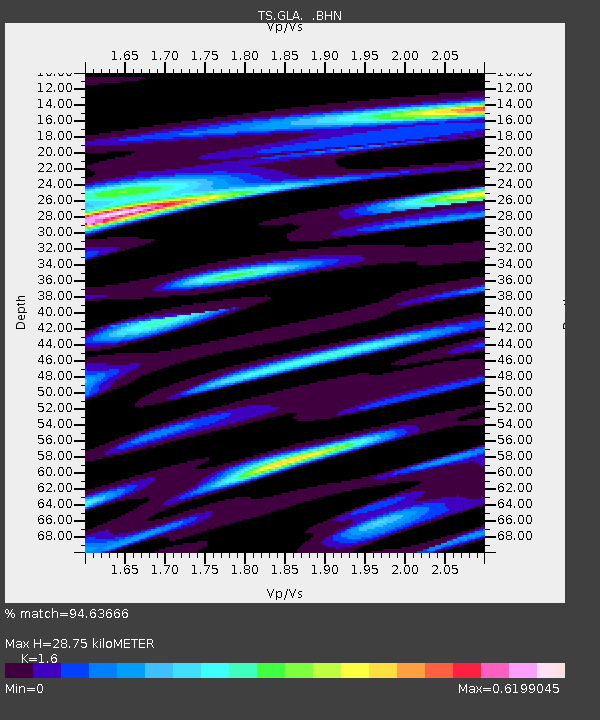
| Estimated Moho Depth: |
28.75 km |
| Estimated Crust Vp/Vs: |
1.60 |
| Assumed Crust Vp: |
6.155 km/s |
| Estimated Crust Vs: |
3.847 km/s |
| Estimated Crust Poisson's Ratio: |
0.18 |
|
| Radial Match: |
94.63666 % |
| Radial Bump: |
400 |
| Transverse Match: |
75.283485 % |
| Transverse Bump: |
400 |
| SOD ConfigId: |
6273 |
| Insert Time: |
2010-02-26 14:13:07.091 +0000 |
| GWidth: |
2.5 |
| Max Bumps: |
400 |
| Tol: |
0.001 |
|

Signal To Noise
| Channel | StoN | STA | LTA |
| TS:GLA: :BHN:19960317T15:00:57.272998Z | 1.1154113 | 2.084539E-7 | 1.8688525E-7 |
| TS:GLA: :BHE:19960317T15:00:57.272998Z | 2.006195 | 2.6294464E-7 | 1.3106634E-7 |
| TS:GLA: :BHZ:19960317T15:00:57.275012Z | 9.1206665 | 1.1336812E-6 | 1.2429807E-7 |
| Arrivals |
| Ps | 2.9 SECOND |
| PpPs | 12 SECOND |
| PsPs/PpSs | 15 SECOND |


