You are here: Home > Network List > TS - TERRAscope (Southern California Seismic Network) Stations List
> Station GLA Glamis, California, USA > Earthquake Result Viewer
GLA Glamis, California, USA - Earthquake Result Viewer

| Earthquake location: |
Near Coast Of Northern Chile |
| Earthquake latitude/longitude: |
-23.9/-70.1 |
| Earthquake time(UTC): |
1996/04/19 (110) 00:19:31 GMT |
| Earthquake Depth: |
50 km |
| Earthquake Magnitude: |
6.0 MB, 6.1 MS, 6.6 UNKNOWN, 6.5 ME |
| Earthquake Catalog/Contributor: |
WHDF/NEIC |
|
| Network: |
TS TERRAscope (Southern California Seismic Network) |
| Station: |
GLA Glamis, California, USA |
| Lat/Lon: |
33.05 N/114.83 W |
| Elevation: |
627 m |
|
| Distance: |
70.9 deg |
| Az: |
321.286 deg |
| Baz: |
137.049 deg |
| Ray Param: |
0.054561224 |
| Estimated Moho Depth: |
28.0 km |
| Estimated Crust Vp/Vs: |
1.62 |
| Assumed Crust Vp: |
6.155 km/s |
| Estimated Crust Vs: |
3.787 km/s |
| Estimated Crust Poisson's Ratio: |
0.20 |
|
| Radial Match: |
90.68207 % |
| Radial Bump: |
400 |
| Transverse Match: |
72.48052 % |
| Transverse Bump: |
400 |
| SOD ConfigId: |
6273 |
| Insert Time: |
2010-02-26 14:13:10.682 +0000 |
| GWidth: |
2.5 |
| Max Bumps: |
400 |
| Tol: |
0.001 |
|
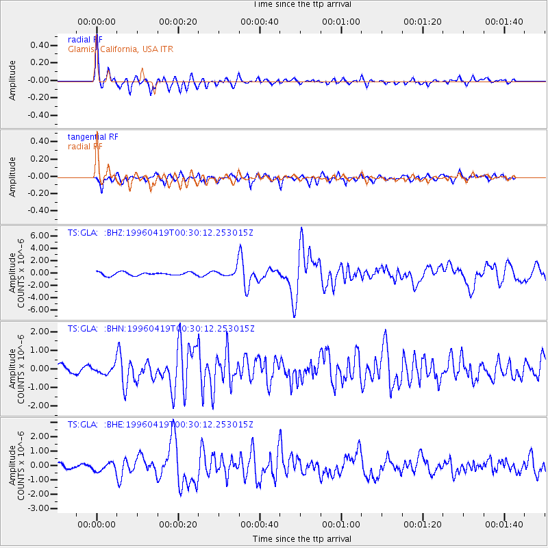
Signal To Noise
| Channel | StoN | STA | LTA |
| TS:GLA: :BHN:19960419T00:30:12.253015Z | 0.9832773 | 2.6719732E-7 | 2.7174156E-7 |
| TS:GLA: :BHE:19960419T00:30:12.253015Z | 1.0438987 | 3.09914E-7 | 2.9688127E-7 |
| TS:GLA: :BHZ:19960419T00:30:12.253015Z | 3.0493639 | 7.9309496E-7 | 2.600854E-7 |
| Arrivals |
| Ps | 2.9 SECOND |
| PpPs | 12 SECOND |
| PsPs/PpSs | 14 SECOND |


