You are here: Home > Network List > TS - TERRAscope (Southern California Seismic Network) Stations List
> Station GLA Glamis, California, USA > Earthquake Result Viewer
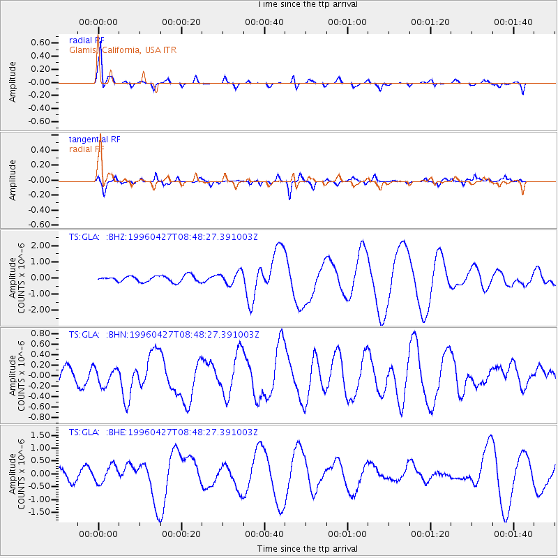
GLA Glamis, California, USA - Earthquake Result Viewer

| Earthquake location: |
South Of Panama |
| Earthquake latitude/longitude: |
2.4/-79.3 |
| Earthquake time(UTC): |
1996/04/27 (118) 08:40:41 GMT |
| Earthquake Depth: |
10 km |
| Earthquake Magnitude: |
4.8 MB, 5.9 MS, 6.2 UNKNOWN, 6.0 MW |
| Earthquake Catalog/Contributor: |
WHDF/NEIC |
|
| Network: |
TS TERRAscope (Southern California Seismic Network) |
| Station: |
GLA Glamis, California, USA |
| Lat/Lon: |
33.05 N/114.83 W |
| Elevation: |
627 m |
|
| Distance: |
45.1 deg |
| Az: |
316.531 deg |
| Baz: |
125.068 deg |
| Ray Param: |
0.07148416 |
| Estimated Moho Depth: |
24.5 km |
| Estimated Crust Vp/Vs: |
1.76 |
| Assumed Crust Vp: |
6.155 km/s |
| Estimated Crust Vs: |
3.502 km/s |
| Estimated Crust Poisson's Ratio: |
0.26 |
|
| Radial Match: |
91.07622 % |
| Radial Bump: |
330 |
| Transverse Match: |
81.578766 % |
| Transverse Bump: |
400 |
| SOD ConfigId: |
6273 |
| Insert Time: |
2010-02-26 14:13:11.810 +0000 |
| GWidth: |
2.5 |
| Max Bumps: |
400 |
| Tol: |
0.001 |
|
Signal To Noise
| Channel | StoN | STA | LTA |
| TS:GLA: :BHN:19960427T08:48:27.391003Z | 0.9444945 | 1.617516E-7 | 1.7125733E-7 |
| TS:GLA: :BHE:19960427T08:48:27.391003Z | 1.5049151 | 3.5675043E-7 | 2.3705684E-7 |
| TS:GLA: :BHZ:19960427T08:48:27.391003Z | 2.0274029 | 3.7972927E-7 | 1.8729838E-7 |
| Arrivals |
| Ps | 3.2 SECOND |
| PpPs | 10 SECOND |
| PsPs/PpSs | 14 SECOND |


