You are here: Home > Network List > CN - Canadian National Seismograph Network Stations List
> Station INK INUVIK, NT > Earthquake Result Viewer
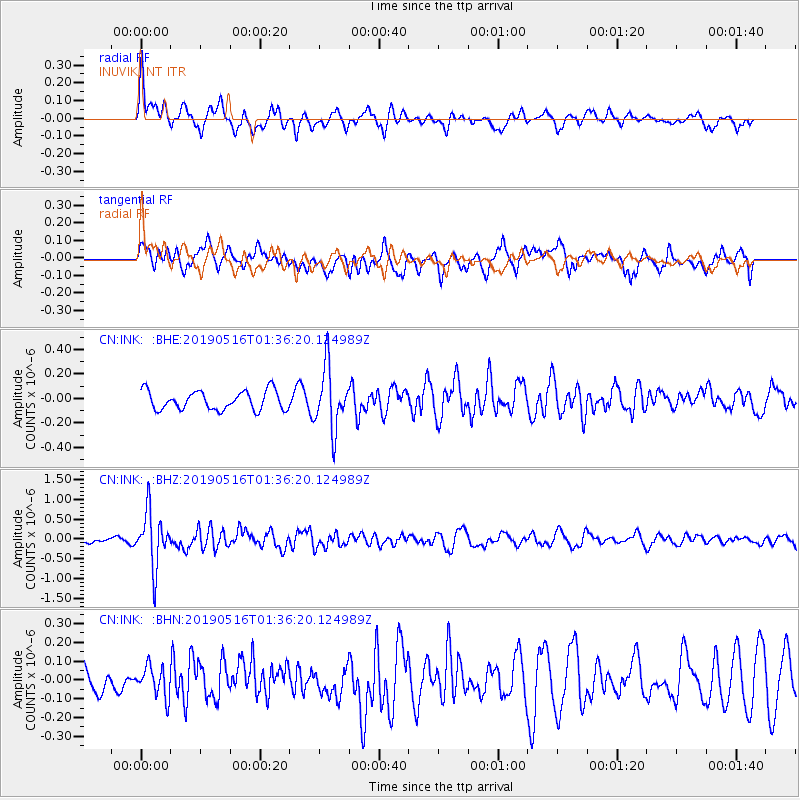
INK INUVIK, NT - Earthquake Result Viewer
*The percent match for this event was below the threshold and hence no stack was calculated.
| Earthquake location: |
New Britain Region, P.N.G. |
| Earthquake latitude/longitude: |
-5.2/152.6 |
| Earthquake time(UTC): |
2019/05/16 (136) 01:23:59 GMT |
| Earthquake Depth: |
25 km |
| Earthquake Magnitude: |
5.7 Mww |
| Earthquake Catalog/Contributor: |
NEIC PDE/us |
|
| Network: |
CN Canadian National Seismograph Network |
| Station: |
INK INUVIK, NT |
| Lat/Lon: |
68.31 N/133.53 W |
| Elevation: |
44 m |
|
| Distance: |
88.9 deg |
| Az: |
20.928 deg |
| Baz: |
253.097 deg |
| Ray Param: |
$rayparam |
*The percent match for this event was below the threshold and hence was not used in the summary stack. |
|
| Radial Match: |
64.25907 % |
| Radial Bump: |
400 |
| Transverse Match: |
64.31845 % |
| Transverse Bump: |
400 |
| SOD ConfigId: |
18369291 |
| Insert Time: |
2019-05-30 01:26:11.872 +0000 |
| GWidth: |
2.5 |
| Max Bumps: |
400 |
| Tol: |
0.001 |
|
Signal To Noise
| Channel | StoN | STA | LTA |
| CN:INK: :BHZ:20190516T01:36:20.124989Z | 7.9663916 | 6.932933E-7 | 8.7027274E-8 |
| CN:INK: :BHN:20190516T01:36:20.124989Z | 1.0608233 | 8.1748546E-8 | 7.7061415E-8 |
| CN:INK: :BHE:20190516T01:36:20.124989Z | 3.2231958 | 2.5015123E-7 | 7.76097E-8 |
| Arrivals |
| Ps | |
| PpPs | |
| PsPs/PpSs | |


