You are here: Home > Network List > TA - USArray Transportable Network (new EarthScope stations) Stations List
> Station M19A Rock Springs, WY, USA > Earthquake Result Viewer
M19A Rock Springs, WY, USA - Earthquake Result Viewer
| Earthquake location: |
Loyalty Islands |
| Earthquake latitude/longitude: |
-20.1/168.9 |
| Earthquake time(UTC): |
2008/04/09 (100) 12:46:12 GMT |
| Earthquake Depth: |
33 km |
| Earthquake Magnitude: |
6.3 MB, 7.3 MS, 7.3 MW, 7.3 MW |
| Earthquake Catalog/Contributor: |
WHDF/NEIC |
|
| Network: |
TA USArray Transportable Network (new EarthScope stations) |
| Station: |
M19A Rock Springs, WY, USA |
| Lat/Lon: |
41.50 N/109.16 W |
| Elevation: |
2080 m |
|
| Distance: |
97.3 deg |
| Az: |
48.566 deg |
| Baz: |
249.763 deg |
| Ray Param: |
0.040251855 |
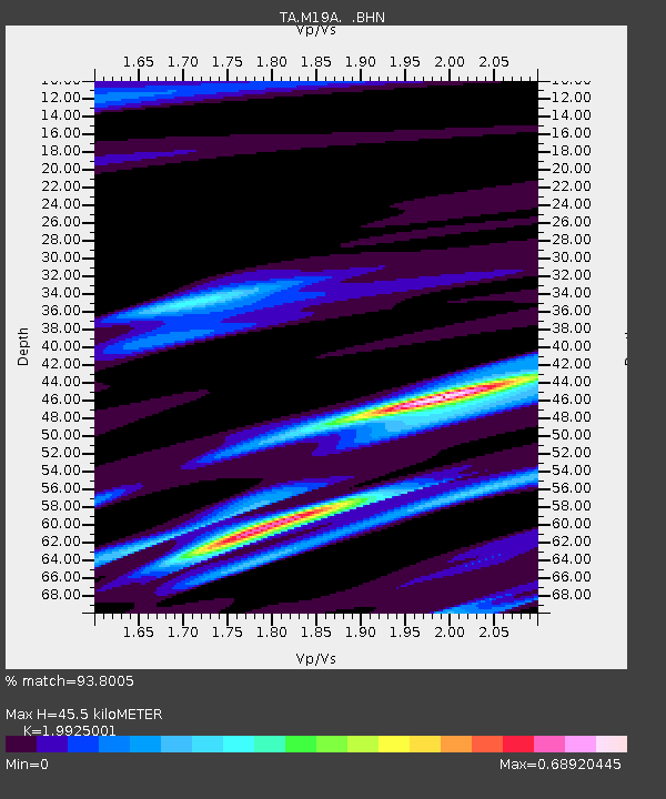
| Estimated Moho Depth: |
45.5 km |
| Estimated Crust Vp/Vs: |
1.99 |
| Assumed Crust Vp: |
6.207 km/s |
| Estimated Crust Vs: |
3.115 km/s |
| Estimated Crust Poisson's Ratio: |
0.33 |
|
| Radial Match: |
93.8005 % |
| Radial Bump: |
248 |
| Transverse Match: |
83.54084 % |
| Transverse Bump: |
400 |
| SOD ConfigId: |
2504 |
| Insert Time: |
2010-03-06 22:34:20.581 +0000 |
| GWidth: |
2.5 |
| Max Bumps: |
400 |
| Tol: |
0.001 |
|
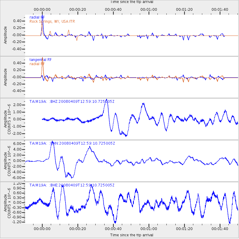
Signal To Noise
| Channel | StoN | STA | LTA |
| TA:M19A: :BHN:20080409T12:59:10.725005Z | 6.3855615 | 1.5312547E-6 | 2.3979953E-7 |
| TA:M19A: :BHE:20080409T12:59:10.725005Z | 0.62431854 | 1.3268051E-7 | 2.1252052E-7 |
| TA:M19A: :BHZ:20080409T12:59:10.725005Z | 3.8941154 | 6.0272333E-7 | 1.5477798E-7 |
| Arrivals |
| Ps | 7.4 SECOND |
| PpPs | 22 SECOND |
| PsPs/PpSs | 29 SECOND |


