You are here: Home > Network List > TS - TERRAscope (Southern California Seismic Network) Stations List
> Station GLA Glamis, California, USA > Earthquake Result Viewer
GLA Glamis, California, USA - Earthquake Result Viewer

| Earthquake location: |
Off East Coast Of Kamchatka |
| Earthquake latitude/longitude: |
51.6/159.1 |
| Earthquake time(UTC): |
1996/06/21 (173) 13:57:10 GMT |
| Earthquake Depth: |
20 km |
| Earthquake Magnitude: |
6.0 MB, 6.6 MS, 7.0 UNKNOWN, 6.5 MS |
| Earthquake Catalog/Contributor: |
WHDF/NEIC |
|
| Network: |
TS TERRAscope (Southern California Seismic Network) |
| Station: |
GLA Glamis, California, USA |
| Lat/Lon: |
33.05 N/114.83 W |
| Elevation: |
627 m |
|
| Distance: |
62.6 deg |
| Az: |
70.686 deg |
| Baz: |
315.465 deg |
| Ray Param: |
0.060097355 |
| Estimated Moho Depth: |
26.5 km |
| Estimated Crust Vp/Vs: |
1.68 |
| Assumed Crust Vp: |
6.155 km/s |
| Estimated Crust Vs: |
3.669 km/s |
| Estimated Crust Poisson's Ratio: |
0.22 |
|
| Radial Match: |
95.79184 % |
| Radial Bump: |
240 |
| Transverse Match: |
85.56779 % |
| Transverse Bump: |
400 |
| SOD ConfigId: |
6273 |
| Insert Time: |
2010-02-26 14:13:14.506 +0000 |
| GWidth: |
2.5 |
| Max Bumps: |
400 |
| Tol: |
0.001 |
|
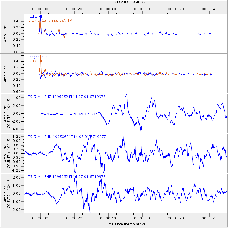
Signal To Noise
| Channel | StoN | STA | LTA |
| TS:GLA: :BHN:19960621T14:07:01.671997Z | 0.9848165 | 9.24316E-8 | 9.385668E-8 |
| TS:GLA: :BHE:19960621T14:07:01.671997Z | 2.4605865 | 1.3694117E-7 | 5.5653867E-8 |
| TS:GLA: :BHZ:19960621T14:07:01.671997Z | 3.2053142 | 2.042669E-7 | 6.3727576E-8 |
| Arrivals |
| Ps | 3.0 SECOND |
| PpPs | 11 SECOND |
| PsPs/PpSs | 14 SECOND |


