You are here: Home > Network List > TA - USArray Transportable Network (new EarthScope stations) Stations List
> Station A21K Barrow, AK, USA > Earthquake Result Viewer
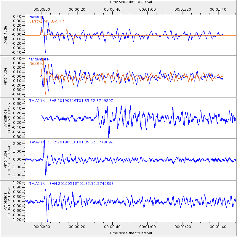
A21K Barrow, AK, USA - Earthquake Result Viewer

| Earthquake location: |
New Britain Region, P.N.G. |
| Earthquake latitude/longitude: |
-5.2/152.6 |
| Earthquake time(UTC): |
2019/05/16 (136) 01:23:59 GMT |
| Earthquake Depth: |
25 km |
| Earthquake Magnitude: |
5.7 Mww |
| Earthquake Catalog/Contributor: |
NEIC PDE/us |
|
| Network: |
TA USArray Transportable Network (new EarthScope stations) |
| Station: |
A21K Barrow, AK, USA |
| Lat/Lon: |
71.32 N/156.62 W |
| Elevation: |
577 m |
|
| Distance: |
83.3 deg |
| Az: |
14.553 deg |
| Baz: |
230.962 deg |
| Ray Param: |
0.046283897 |
| Estimated Moho Depth: |
32.25 km |
| Estimated Crust Vp/Vs: |
1.71 |
| Assumed Crust Vp: |
6.048 km/s |
| Estimated Crust Vs: |
3.542 km/s |
| Estimated Crust Poisson's Ratio: |
0.24 |
|
| Radial Match: |
85.85585 % |
| Radial Bump: |
400 |
| Transverse Match: |
81.32965 % |
| Transverse Bump: |
400 |
| SOD ConfigId: |
18369291 |
| Insert Time: |
2019-05-30 01:27:48.953 +0000 |
| GWidth: |
2.5 |
| Max Bumps: |
400 |
| Tol: |
0.001 |
|
Signal To Noise
| Channel | StoN | STA | LTA |
| TA:A21K: :BHZ:20190516T01:35:52.374989Z | 9.486776 | 9.957765E-7 | 1.049647E-7 |
| TA:A21K: :BHN:20190516T01:35:52.374989Z | 6.256548 | 4.9947903E-7 | 7.983301E-8 |
| TA:A21K: :BHE:20190516T01:35:52.374989Z | 3.711374 | 2.1558857E-7 | 5.8088613E-8 |
| Arrivals |
| Ps | 3.9 SECOND |
| PpPs | 14 SECOND |
| PsPs/PpSs | 18 SECOND |


