You are here: Home > Network List > TA - USArray Transportable Network (new EarthScope stations) Stations List
> Station B18K Kokolik River, AK, USA > Earthquake Result Viewer
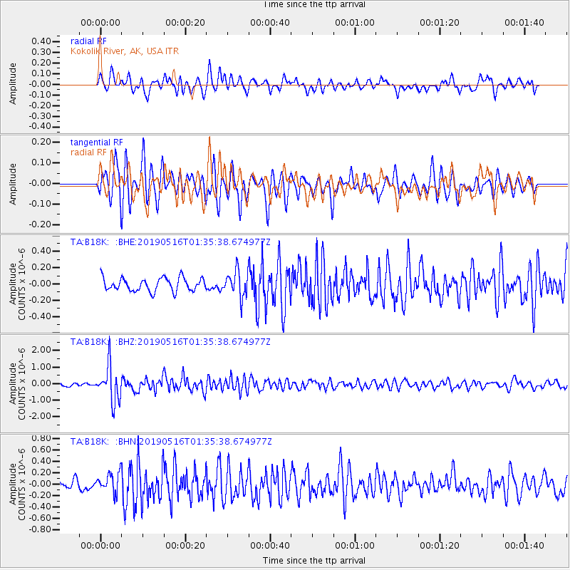
B18K Kokolik River, AK, USA - Earthquake Result Viewer
*The percent match for this event was below the threshold and hence no stack was calculated.
| Earthquake location: |
New Britain Region, P.N.G. |
| Earthquake latitude/longitude: |
-5.2/152.6 |
| Earthquake time(UTC): |
2019/05/16 (136) 01:23:59 GMT |
| Earthquake Depth: |
25 km |
| Earthquake Magnitude: |
5.7 Mww |
| Earthquake Catalog/Contributor: |
NEIC PDE/us |
|
| Network: |
TA USArray Transportable Network (new EarthScope stations) |
| Station: |
B18K Kokolik River, AK, USA |
| Lat/Lon: |
69.36 N/161.80 W |
| Elevation: |
222 m |
|
| Distance: |
80.6 deg |
| Az: |
14.869 deg |
| Baz: |
226.127 deg |
| Ray Param: |
$rayparam |
*The percent match for this event was below the threshold and hence was not used in the summary stack. |
|
| Radial Match: |
74.18995 % |
| Radial Bump: |
400 |
| Transverse Match: |
76.56877 % |
| Transverse Bump: |
400 |
| SOD ConfigId: |
18369291 |
| Insert Time: |
2019-05-30 01:27:50.385 +0000 |
| GWidth: |
2.5 |
| Max Bumps: |
400 |
| Tol: |
0.001 |
|
Signal To Noise
| Channel | StoN | STA | LTA |
| TA:B18K: :BHZ:20190516T01:35:38.674977Z | 12.662179 | 1.0959137E-6 | 8.655017E-8 |
| TA:B18K: :BHN:20190516T01:35:38.674977Z | 1.9448199 | 1.7338851E-7 | 8.9154014E-8 |
| TA:B18K: :BHE:20190516T01:35:38.674977Z | 1.9983135 | 1.6155116E-7 | 8.084375E-8 |
| Arrivals |
| Ps | |
| PpPs | |
| PsPs/PpSs | |


