You are here: Home > Network List > TA - USArray Transportable Network (new EarthScope stations) Stations List
> Station D23K Nanushuk River, AK USA > Earthquake Result Viewer
D23K Nanushuk River, AK USA - Earthquake Result Viewer

| Earthquake location: |
New Britain Region, P.N.G. |
| Earthquake latitude/longitude: |
-5.2/152.6 |
| Earthquake time(UTC): |
2019/05/16 (136) 01:23:59 GMT |
| Earthquake Depth: |
25 km |
| Earthquake Magnitude: |
5.7 Mww |
| Earthquake Catalog/Contributor: |
NEIC PDE/us |
|
| Network: |
TA USArray Transportable Network (new EarthScope stations) |
| Station: |
D23K Nanushuk River, AK USA |
| Lat/Lon: |
68.97 N/150.68 W |
| Elevation: |
406 m |
|
| Distance: |
83.5 deg |
| Az: |
17.68 deg |
| Baz: |
236.903 deg |
| Ray Param: |
0.046108294 |
| Estimated Moho Depth: |
37.0 km |
| Estimated Crust Vp/Vs: |
1.96 |
| Assumed Crust Vp: |
6.221 km/s |
| Estimated Crust Vs: |
3.182 km/s |
| Estimated Crust Poisson's Ratio: |
0.32 |
|
| Radial Match: |
82.57075 % |
| Radial Bump: |
388 |
| Transverse Match: |
73.91656 % |
| Transverse Bump: |
369 |
| SOD ConfigId: |
18369291 |
| Insert Time: |
2019-05-30 01:27:59.568 +0000 |
| GWidth: |
2.5 |
| Max Bumps: |
400 |
| Tol: |
0.001 |
|
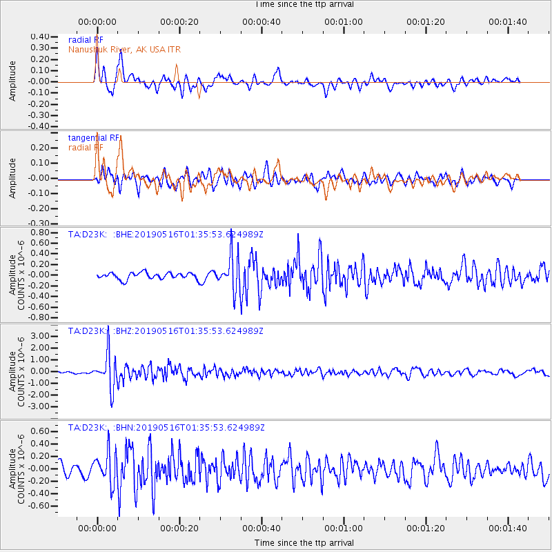
Signal To Noise
| Channel | StoN | STA | LTA |
| TA:D23K: :BHZ:20190516T01:35:53.624989Z | 16.7471 | 1.4992045E-6 | 8.952024E-8 |
| TA:D23K: :BHN:20190516T01:35:53.624989Z | 3.3924806 | 2.5749554E-7 | 7.5901845E-8 |
| TA:D23K: :BHE:20190516T01:35:53.624989Z | 5.5294113 | 3.3509733E-7 | 6.0602716E-8 |
| Arrivals |
| Ps | 5.8 SECOND |
| PpPs | 17 SECOND |
| PsPs/PpSs | 23 SECOND |


