You are here: Home > Network List > TA - USArray Transportable Network (new EarthScope stations) Stations List
> Station E18K Tukpahlearik Creek, AK, USA > Earthquake Result Viewer
E18K Tukpahlearik Creek, AK, USA - Earthquake Result Viewer
| Earthquake location: |
New Britain Region, P.N.G. |
| Earthquake latitude/longitude: |
-5.2/152.6 |
| Earthquake time(UTC): |
2019/05/16 (136) 01:23:59 GMT |
| Earthquake Depth: |
25 km |
| Earthquake Magnitude: |
5.7 Mww |
| Earthquake Catalog/Contributor: |
NEIC PDE/us |
|
| Network: |
TA USArray Transportable Network (new EarthScope stations) |
| Station: |
E18K Tukpahlearik Creek, AK, USA |
| Lat/Lon: |
67.42 N/160.60 W |
| Elevation: |
297 m |
|
| Distance: |
79.6 deg |
| Az: |
16.622 deg |
| Baz: |
227.541 deg |
| Ray Param: |
0.048795935 |
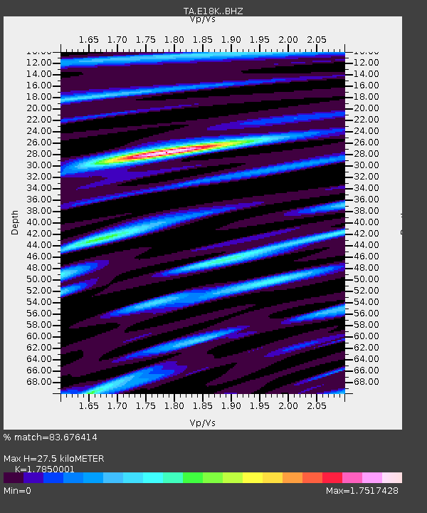
| Estimated Moho Depth: |
27.5 km |
| Estimated Crust Vp/Vs: |
1.79 |
| Assumed Crust Vp: |
6.276 km/s |
| Estimated Crust Vs: |
3.516 km/s |
| Estimated Crust Poisson's Ratio: |
0.27 |
|
| Radial Match: |
83.676414 % |
| Radial Bump: |
366 |
| Transverse Match: |
75.52787 % |
| Transverse Bump: |
387 |
| SOD ConfigId: |
18369291 |
| Insert Time: |
2019-05-30 01:28:02.868 +0000 |
| GWidth: |
2.5 |
| Max Bumps: |
400 |
| Tol: |
0.001 |
|

Signal To Noise
| Channel | StoN | STA | LTA |
| TA:E18K: :BHZ:20190516T01:35:33.249989Z | 18.919176 | 8.0828926E-7 | 4.272328E-8 |
| TA:E18K: :BHN:20190516T01:35:33.249989Z | 5.626837 | 3.2722127E-7 | 5.8153685E-8 |
| TA:E18K: :BHE:20190516T01:35:33.249989Z | 5.1793213 | 2.5417694E-7 | 4.907534E-8 |
| Arrivals |
| Ps | 3.5 SECOND |
| PpPs | 12 SECOND |
| PsPs/PpSs | 15 SECOND |


