You are here: Home > Network List > TA - USArray Transportable Network (new EarthScope stations) Stations List
> Station E19K Redstone River, AK, USA > Earthquake Result Viewer
E19K Redstone River, AK, USA - Earthquake Result Viewer
| Earthquake location: |
New Britain Region, P.N.G. |
| Earthquake latitude/longitude: |
-5.2/152.6 |
| Earthquake time(UTC): |
2019/05/16 (136) 01:23:59 GMT |
| Earthquake Depth: |
25 km |
| Earthquake Magnitude: |
5.7 Mww |
| Earthquake Catalog/Contributor: |
NEIC PDE/us |
|
| Network: |
TA USArray Transportable Network (new EarthScope stations) |
| Station: |
E19K Redstone River, AK, USA |
| Lat/Lon: |
67.46 N/157.23 W |
| Elevation: |
441 m |
|
| Distance: |
80.6 deg |
| Az: |
17.458 deg |
| Baz: |
230.794 deg |
| Ray Param: |
0.04810835 |
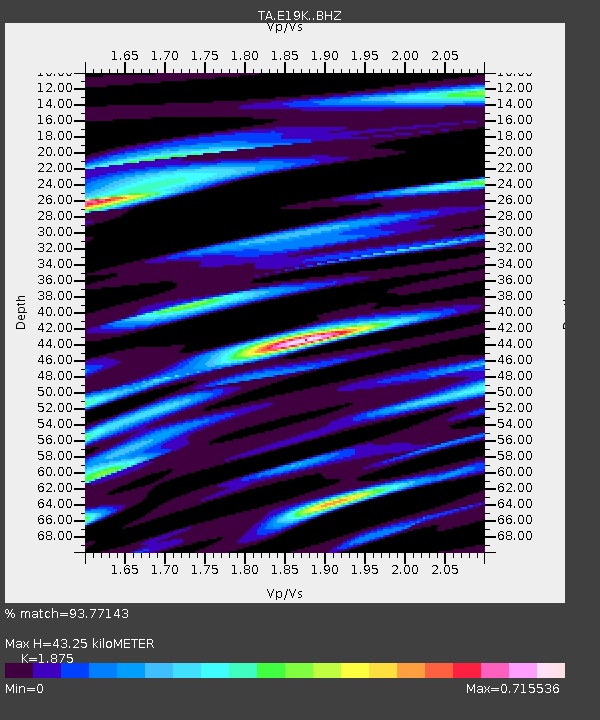
| Estimated Moho Depth: |
43.25 km |
| Estimated Crust Vp/Vs: |
1.88 |
| Assumed Crust Vp: |
6.577 km/s |
| Estimated Crust Vs: |
3.508 km/s |
| Estimated Crust Poisson's Ratio: |
0.30 |
|
| Radial Match: |
93.77143 % |
| Radial Bump: |
322 |
| Transverse Match: |
90.821365 % |
| Transverse Bump: |
400 |
| SOD ConfigId: |
18369291 |
| Insert Time: |
2019-05-30 01:28:03.273 +0000 |
| GWidth: |
2.5 |
| Max Bumps: |
400 |
| Tol: |
0.001 |
|

Signal To Noise
| Channel | StoN | STA | LTA |
| TA:E19K: :BHZ:20190516T01:35:38.650013Z | 28.394331 | 1.4822094E-6 | 5.2200892E-8 |
| TA:E19K: :BHN:20190516T01:35:38.650013Z | 5.867941 | 2.519736E-7 | 4.2940716E-8 |
| TA:E19K: :BHE:20190516T01:35:38.650013Z | 16.479578 | 4.461485E-7 | 2.7072812E-8 |
| Arrivals |
| Ps | 5.9 SECOND |
| PpPs | 18 SECOND |
| PsPs/PpSs | 24 SECOND |


