You are here: Home > Network List > TA - USArray Transportable Network (new EarthScope stations) Stations List
> Station E20K Nigu River, AK, USA > Earthquake Result Viewer
E20K Nigu River, AK, USA - Earthquake Result Viewer
| Earthquake location: |
New Britain Region, P.N.G. |
| Earthquake latitude/longitude: |
-5.2/152.6 |
| Earthquake time(UTC): |
2019/05/16 (136) 01:23:59 GMT |
| Earthquake Depth: |
25 km |
| Earthquake Magnitude: |
5.7 Mww |
| Earthquake Catalog/Contributor: |
NEIC PDE/us |
|
| Network: |
TA USArray Transportable Network (new EarthScope stations) |
| Station: |
E20K Nigu River, AK, USA |
| Lat/Lon: |
68.26 N/156.19 W |
| Elevation: |
866 m |
|
| Distance: |
81.5 deg |
| Az: |
17.074 deg |
| Baz: |
231.7 deg |
| Ray Param: |
0.047545344 |
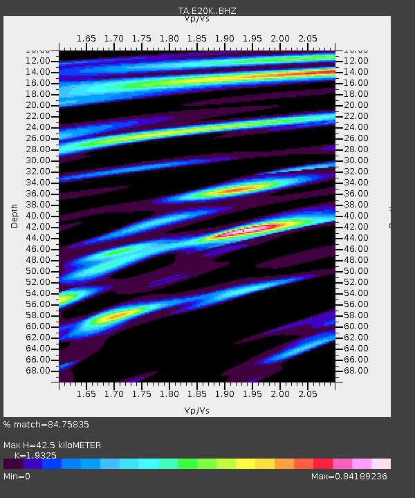
| Estimated Moho Depth: |
42.5 km |
| Estimated Crust Vp/Vs: |
1.93 |
| Assumed Crust Vp: |
6.221 km/s |
| Estimated Crust Vs: |
3.219 km/s |
| Estimated Crust Poisson's Ratio: |
0.32 |
|
| Radial Match: |
84.75835 % |
| Radial Bump: |
400 |
| Transverse Match: |
84.30507 % |
| Transverse Bump: |
400 |
| SOD ConfigId: |
18369291 |
| Insert Time: |
2019-05-30 01:28:04.753 +0000 |
| GWidth: |
2.5 |
| Max Bumps: |
400 |
| Tol: |
0.001 |
|

Signal To Noise
| Channel | StoN | STA | LTA |
| TA:E20K: :BHZ:20190516T01:35:42.950001Z | 13.477175 | 1.0252002E-6 | 7.606937E-8 |
| TA:E20K: :BHN:20190516T01:35:42.950001Z | 3.2577884 | 1.5412145E-7 | 4.7308614E-8 |
| TA:E20K: :BHE:20190516T01:35:42.950001Z | 7.035573 | 2.7409126E-7 | 3.8957918E-8 |
| Arrivals |
| Ps | 6.5 SECOND |
| PpPs | 20 SECOND |
| PsPs/PpSs | 26 SECOND |


