You are here: Home > Network List > TA - USArray Transportable Network (new EarthScope stations) Stations List
> Station E23K Chandalar, AK, USA > Earthquake Result Viewer
E23K Chandalar, AK, USA - Earthquake Result Viewer
| Earthquake location: |
New Britain Region, P.N.G. |
| Earthquake latitude/longitude: |
-5.2/152.6 |
| Earthquake time(UTC): |
2019/05/16 (136) 01:23:59 GMT |
| Earthquake Depth: |
25 km |
| Earthquake Magnitude: |
5.7 Mww |
| Earthquake Catalog/Contributor: |
NEIC PDE/us |
|
| Network: |
TA USArray Transportable Network (new EarthScope stations) |
| Station: |
E23K Chandalar, AK, USA |
| Lat/Lon: |
68.06 N/149.62 W |
| Elevation: |
1084 m |
|
| Distance: |
83.4 deg |
| Az: |
18.666 deg |
| Baz: |
238.006 deg |
| Ray Param: |
0.04622217 |
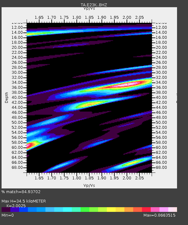
| Estimated Moho Depth: |
34.5 km |
| Estimated Crust Vp/Vs: |
2.00 |
| Assumed Crust Vp: |
6.316 km/s |
| Estimated Crust Vs: |
3.154 km/s |
| Estimated Crust Poisson's Ratio: |
0.33 |
|
| Radial Match: |
84.93702 % |
| Radial Bump: |
400 |
| Transverse Match: |
75.7971 % |
| Transverse Bump: |
390 |
| SOD ConfigId: |
18369291 |
| Insert Time: |
2019-05-30 01:28:05.848 +0000 |
| GWidth: |
2.5 |
| Max Bumps: |
400 |
| Tol: |
0.001 |
|

Signal To Noise
| Channel | StoN | STA | LTA |
| TA:E23K: :BHZ:20190516T01:35:52.825001Z | 13.637591 | 9.573785E-7 | 7.020144E-8 |
| TA:E23K: :BHN:20190516T01:35:52.825001Z | 2.118262 | 1.5501277E-7 | 7.317922E-8 |
| TA:E23K: :BHE:20190516T01:35:52.825001Z | 4.7133713 | 2.1835346E-7 | 4.6326388E-8 |
| Arrivals |
| Ps | 5.6 SECOND |
| PpPs | 16 SECOND |
| PsPs/PpSs | 22 SECOND |


