You are here: Home > Network List > TA - USArray Transportable Network (new EarthScope stations) Stations List
> Station G21K Allakaket, AK, USA > Earthquake Result Viewer
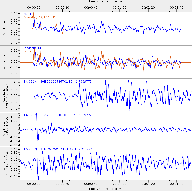
G21K Allakaket, AK, USA - Earthquake Result Viewer
*The percent match for this event was below the threshold and hence no stack was calculated.
| Earthquake location: |
New Britain Region, P.N.G. |
| Earthquake latitude/longitude: |
-5.2/152.6 |
| Earthquake time(UTC): |
2019/05/16 (136) 01:23:59 GMT |
| Earthquake Depth: |
25 km |
| Earthquake Magnitude: |
5.7 Mww |
| Earthquake Catalog/Contributor: |
NEIC PDE/us |
|
| Network: |
TA USArray Transportable Network (new EarthScope stations) |
| Station: |
G21K Allakaket, AK, USA |
| Lat/Lon: |
66.52 N/153.51 W |
| Elevation: |
446 m |
|
| Distance: |
81.2 deg |
| Az: |
19.119 deg |
| Baz: |
234.482 deg |
| Ray Param: |
$rayparam |
*The percent match for this event was below the threshold and hence was not used in the summary stack. |
|
| Radial Match: |
70.86185 % |
| Radial Bump: |
400 |
| Transverse Match: |
74.77472 % |
| Transverse Bump: |
400 |
| SOD ConfigId: |
18369291 |
| Insert Time: |
2019-05-30 01:28:19.645 +0000 |
| GWidth: |
2.5 |
| Max Bumps: |
400 |
| Tol: |
0.001 |
|
Signal To Noise
| Channel | StoN | STA | LTA |
| TA:G21K: :BHZ:20190516T01:35:41.799977Z | 11.924738 | 7.771797E-7 | 6.517374E-8 |
| TA:G21K: :BHN:20190516T01:35:41.799977Z | 3.2039132 | 2.1785985E-7 | 6.799805E-8 |
| TA:G21K: :BHE:20190516T01:35:41.799977Z | 2.8508928 | 1.7772568E-7 | 6.234036E-8 |
| Arrivals |
| Ps | |
| PpPs | |
| PsPs/PpSs | |


