You are here: Home > Network List > TA - USArray Transportable Network (new EarthScope stations) Stations List
> Station H16K Elim, AK, USA > Earthquake Result Viewer
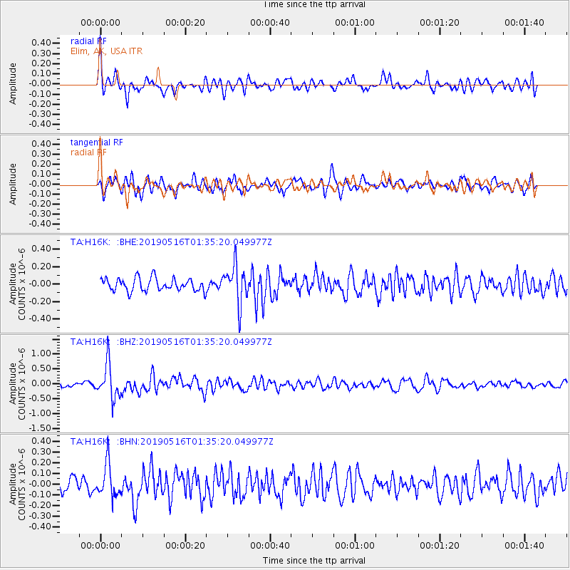
H16K Elim, AK, USA - Earthquake Result Viewer
*The percent match for this event was below the threshold and hence no stack was calculated.
| Earthquake location: |
New Britain Region, P.N.G. |
| Earthquake latitude/longitude: |
-5.2/152.6 |
| Earthquake time(UTC): |
2019/05/16 (136) 01:23:59 GMT |
| Earthquake Depth: |
25 km |
| Earthquake Magnitude: |
5.7 Mww |
| Earthquake Catalog/Contributor: |
NEIC PDE/us |
|
| Network: |
TA USArray Transportable Network (new EarthScope stations) |
| Station: |
H16K Elim, AK, USA |
| Lat/Lon: |
64.64 N/162.24 W |
| Elevation: |
216 m |
|
| Distance: |
77.2 deg |
| Az: |
18.242 deg |
| Baz: |
226.372 deg |
| Ray Param: |
$rayparam |
*The percent match for this event was below the threshold and hence was not used in the summary stack. |
|
| Radial Match: |
66.13906 % |
| Radial Bump: |
400 |
| Transverse Match: |
70.24335 % |
| Transverse Bump: |
400 |
| SOD ConfigId: |
18369291 |
| Insert Time: |
2019-05-30 01:28:24.651 +0000 |
| GWidth: |
2.5 |
| Max Bumps: |
400 |
| Tol: |
0.001 |
|
Signal To Noise
| Channel | StoN | STA | LTA |
| TA:H16K: :BHZ:20190516T01:35:20.049977Z | 8.410304 | 5.951284E-7 | 7.076182E-8 |
| TA:H16K: :BHN:20190516T01:35:20.049977Z | 2.5589538 | 1.5676504E-7 | 6.1261375E-8 |
| TA:H16K: :BHE:20190516T01:35:20.049977Z | 3.1101418 | 2.2637163E-7 | 7.2784985E-8 |
| Arrivals |
| Ps | |
| PpPs | |
| PsPs/PpSs | |


