You are here: Home > Network List > TA - USArray Transportable Network (new EarthScope stations) Stations List
> Station J16K Anvik River, AK, USA > Earthquake Result Viewer
J16K Anvik River, AK, USA - Earthquake Result Viewer
| Earthquake location: |
New Britain Region, P.N.G. |
| Earthquake latitude/longitude: |
-5.2/152.6 |
| Earthquake time(UTC): |
2019/05/16 (136) 01:23:59 GMT |
| Earthquake Depth: |
25 km |
| Earthquake Magnitude: |
5.7 Mww |
| Earthquake Catalog/Contributor: |
NEIC PDE/us |
|
| Network: |
TA USArray Transportable Network (new EarthScope stations) |
| Station: |
J16K Anvik River, AK, USA |
| Lat/Lon: |
63.28 N/160.60 W |
| Elevation: |
328 m |
|
| Distance: |
76.8 deg |
| Az: |
19.77 deg |
| Baz: |
228.183 deg |
| Ray Param: |
0.050689243 |
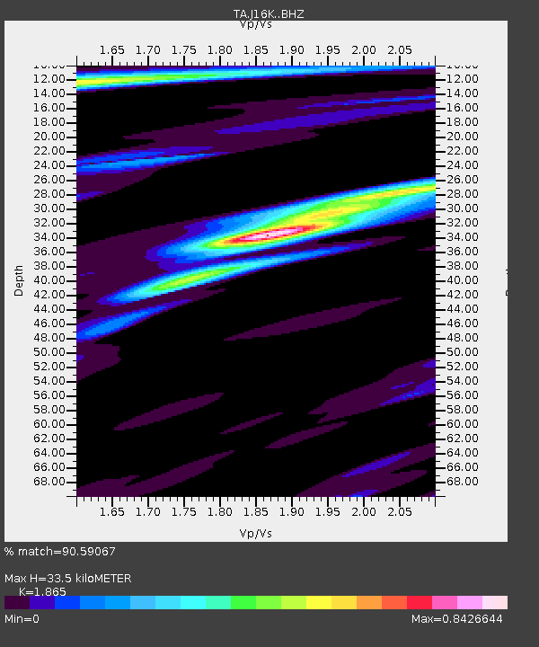
| Estimated Moho Depth: |
33.5 km |
| Estimated Crust Vp/Vs: |
1.87 |
| Assumed Crust Vp: |
6.276 km/s |
| Estimated Crust Vs: |
3.365 km/s |
| Estimated Crust Poisson's Ratio: |
0.30 |
|
| Radial Match: |
90.59067 % |
| Radial Bump: |
369 |
| Transverse Match: |
86.03489 % |
| Transverse Bump: |
391 |
| SOD ConfigId: |
18369291 |
| Insert Time: |
2019-05-30 01:28:36.910 +0000 |
| GWidth: |
2.5 |
| Max Bumps: |
400 |
| Tol: |
0.001 |
|

Signal To Noise
| Channel | StoN | STA | LTA |
| TA:J16K: :BHZ:20190516T01:35:17.874989Z | 20.891624 | 1.1666825E-6 | 5.5844513E-8 |
| TA:J16K: :BHN:20190516T01:35:17.874989Z | 4.8194113 | 3.002804E-7 | 6.230644E-8 |
| TA:J16K: :BHE:20190516T01:35:17.874989Z | 5.414929 | 2.5935452E-7 | 4.7896197E-8 |
| Arrivals |
| Ps | 4.7 SECOND |
| PpPs | 15 SECOND |
| PsPs/PpSs | 20 SECOND |


