You are here: Home > Network List > UU - University of Utah Regional Network Stations List
> Station CCUT Cedar City, UT, USA > Earthquake Result Viewer
CCUT Cedar City, UT, USA - Earthquake Result Viewer
| Earthquake location: |
Central Italy |
| Earthquake latitude/longitude: |
42.9/13.1 |
| Earthquake time(UTC): |
2016/10/30 (304) 06:40:19 GMT |
| Earthquake Depth: |
10 km |
| Earthquake Magnitude: |
6.6 MWW, 6.6 MWR |
| Earthquake Catalog/Contributor: |
NEIC PDE/NEIC COMCAT |
|
| Network: |
UU University of Utah Regional Network |
| Station: |
CCUT Cedar City, UT, USA |
| Lat/Lon: |
37.55 N/113.36 W |
| Elevation: |
2127 m |
|
| Distance: |
86.3 deg |
| Az: |
320.162 deg |
| Baz: |
36.349 deg |
| Ray Param: |
0.04412966 |
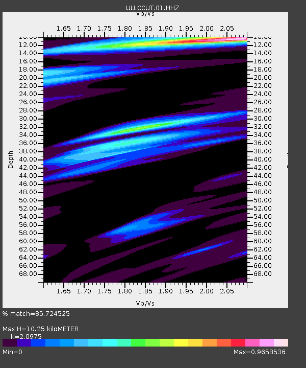
| Estimated Moho Depth: |
10.25 km |
| Estimated Crust Vp/Vs: |
2.10 |
| Assumed Crust Vp: |
6.194 km/s |
| Estimated Crust Vs: |
2.953 km/s |
| Estimated Crust Poisson's Ratio: |
0.35 |
|
| Radial Match: |
85.724525 % |
| Radial Bump: |
382 |
| Transverse Match: |
75.16691 % |
| Transverse Bump: |
355 |
| SOD ConfigId: |
1815711 |
| Insert Time: |
2016-11-13 06:47:17.957 +0000 |
| GWidth: |
2.5 |
| Max Bumps: |
400 |
| Tol: |
0.001 |
|
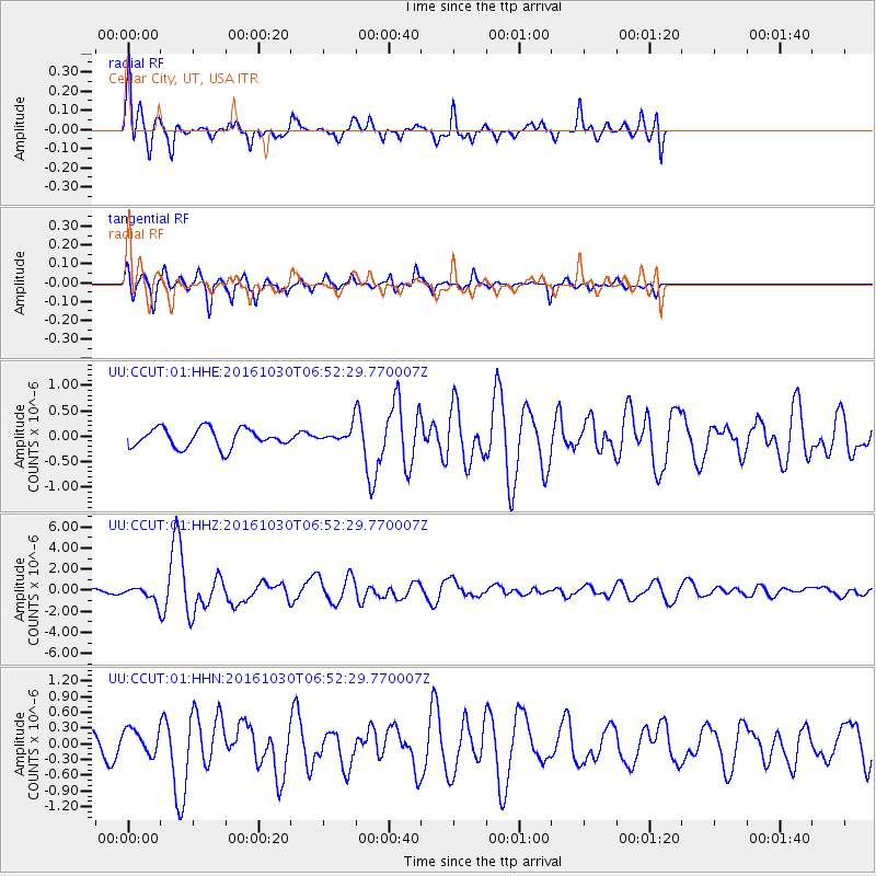
Signal To Noise
| Channel | StoN | STA | LTA |
| UU:CCUT:01:HHZ:20161030T06:52:29.770007Z | 3.6277006 | 6.2881634E-7 | 1.7333744E-7 |
| UU:CCUT:01:HHN:20161030T06:52:29.770007Z | 1.5084713 | 2.3819827E-7 | 1.5790707E-7 |
| UU:CCUT:01:HHE:20161030T06:52:29.770007Z | 0.7164953 | 1.3299102E-7 | 1.8561326E-7 |
| Arrivals |
| Ps | 1.8 SECOND |
| PpPs | 5.0 SECOND |
| PsPs/PpSs | 6.9 SECOND |


