You are here: Home > Network List > TA - USArray Transportable Network (new EarthScope stations) Stations List
> Station M19A Rock Springs, WY, USA > Earthquake Result Viewer
M19A Rock Springs, WY, USA - Earthquake Result Viewer
*The percent match for this event was below the threshold and hence no stack was calculated.
| Earthquake location: |
Solomon Islands |
| Earthquake latitude/longitude: |
-8.9/159.6 |
| Earthquake time(UTC): |
2008/11/21 (326) 07:05:34 GMT |
| Earthquake Depth: |
118 km |
| Earthquake Magnitude: |
6.0 MB, 6.1 MW, 6.0 MW |
| Earthquake Catalog/Contributor: |
WHDF/NEIC |
|
| Network: |
TA USArray Transportable Network (new EarthScope stations) |
| Station: |
M19A Rock Springs, WY, USA |
| Lat/Lon: |
41.50 N/109.16 W |
| Elevation: |
2080 m |
|
| Distance: |
96.8 deg |
| Az: |
49.136 deg |
| Baz: |
264.141 deg |
| Ray Param: |
$rayparam |
*The percent match for this event was below the threshold and hence was not used in the summary stack. |
|
| Radial Match: |
61.349525 % |
| Radial Bump: |
341 |
| Transverse Match: |
38.24844 % |
| Transverse Bump: |
289 |
| SOD ConfigId: |
2658 |
| Insert Time: |
2010-03-06 22:35:13.985 +0000 |
| GWidth: |
2.5 |
| Max Bumps: |
400 |
| Tol: |
0.001 |
|
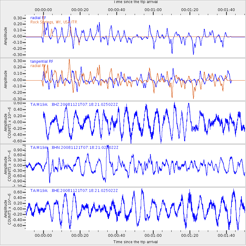
Signal To Noise
| Channel | StoN | STA | LTA |
| TA:M19A: :BHN:20081121T07:18:21.025022Z | 1.9303904 | 4.663482E-7 | 2.4158234E-7 |
| TA:M19A: :BHE:20081121T07:18:21.025022Z | 0.5656219 | 1.901736E-7 | 3.3622035E-7 |
| TA:M19A: :BHZ:20081121T07:18:21.025022Z | 1.200334 | 2.915388E-7 | 2.428814E-7 |
| Arrivals |
| Ps | |
| PpPs | |
| PsPs/PpSs | |


