You are here: Home > Network List > TA - USArray Transportable Network (new EarthScope stations) Stations List
> Station M19A Rock Springs, WY, USA > Earthquake Result Viewer
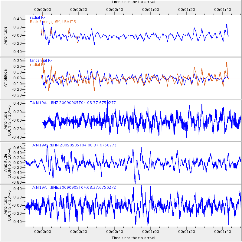
M19A Rock Springs, WY, USA - Earthquake Result Viewer
*The percent match for this event was below the threshold and hence no stack was calculated.
| Earthquake location: |
Southern Peru |
| Earthquake latitude/longitude: |
-15.1/-70.2 |
| Earthquake time(UTC): |
2009/09/05 (248) 03:58:39 GMT |
| Earthquake Depth: |
210 km |
| Earthquake Magnitude: |
5.8 MW, 5.2 MB, 5.8 MW |
| Earthquake Catalog/Contributor: |
WHDF/NEIC |
|
| Network: |
TA USArray Transportable Network (new EarthScope stations) |
| Station: |
M19A Rock Springs, WY, USA |
| Lat/Lon: |
41.50 N/109.16 W |
| Elevation: |
2080 m |
|
| Distance: |
66.8 deg |
| Az: |
329.128 deg |
| Baz: |
138.715 deg |
| Ray Param: |
$rayparam |
*The percent match for this event was below the threshold and hence was not used in the summary stack. |
|
| Radial Match: |
68.862564 % |
| Radial Bump: |
400 |
| Transverse Match: |
55.637226 % |
| Transverse Bump: |
400 |
| SOD ConfigId: |
2622 |
| Insert Time: |
2010-03-06 22:35:19.545 +0000 |
| GWidth: |
2.5 |
| Max Bumps: |
400 |
| Tol: |
0.001 |
|
Signal To Noise
| Channel | StoN | STA | LTA |
| TA:M19A: :BHN:20090905T04:08:37.675027Z | 2.747134 | 3.075263E-7 | 1.1194441E-7 |
| TA:M19A: :BHE:20090905T04:08:37.675027Z | 1.0957218 | 1.2861464E-7 | 1.17378924E-7 |
| TA:M19A: :BHZ:20090905T04:08:37.675027Z | 0.9731504 | 7.846964E-8 | 8.063465E-8 |
| Arrivals |
| Ps | |
| PpPs | |
| PsPs/PpSs | |


