You are here: Home > Network List > TA - USArray Transportable Network (new EarthScope stations) Stations List
> Station M19A Rock Springs, WY, USA > Earthquake Result Viewer
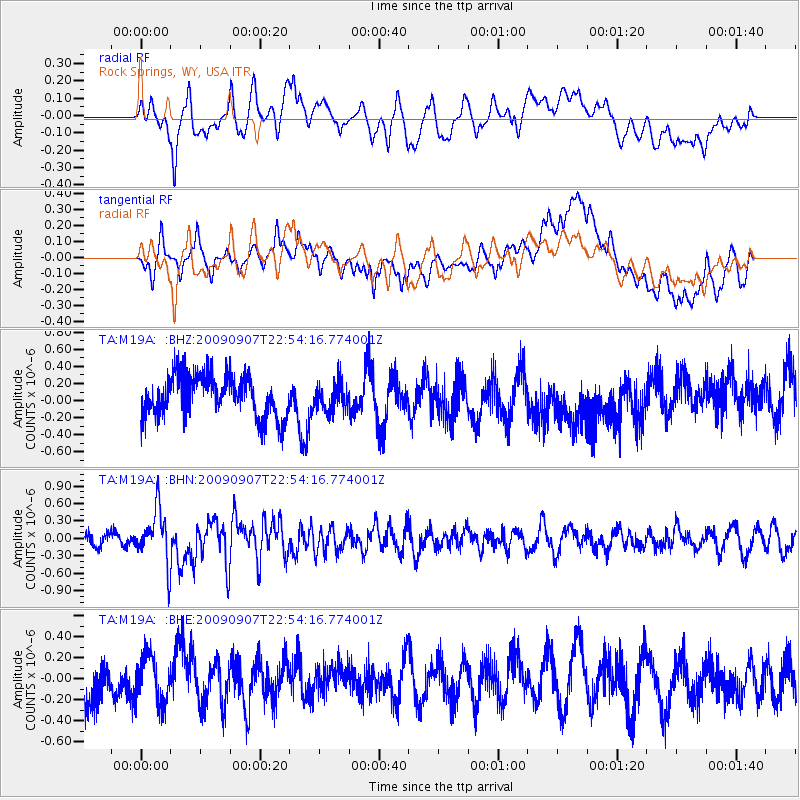
M19A Rock Springs, WY, USA - Earthquake Result Viewer
*The percent match for this event was below the threshold and hence no stack was calculated.
| Earthquake location: |
Northwestern Caucasus |
| Earthquake latitude/longitude: |
42.7/43.4 |
| Earthquake time(UTC): |
2009/09/07 (250) 22:41:37 GMT |
| Earthquake Depth: |
15 km |
| Earthquake Magnitude: |
5.7 MB, 5.8 MS, 6.0 MW, 5.9 MW |
| Earthquake Catalog/Contributor: |
WHDF/NEIC |
|
| Network: |
TA USArray Transportable Network (new EarthScope stations) |
| Station: |
M19A Rock Springs, WY, USA |
| Lat/Lon: |
41.50 N/109.16 W |
| Elevation: |
2080 m |
|
| Distance: |
92.6 deg |
| Az: |
339.755 deg |
| Baz: |
19.867 deg |
| Ray Param: |
$rayparam |
*The percent match for this event was below the threshold and hence was not used in the summary stack. |
|
| Radial Match: |
59.323704 % |
| Radial Bump: |
400 |
| Transverse Match: |
53.01748 % |
| Transverse Bump: |
400 |
| SOD ConfigId: |
2622 |
| Insert Time: |
2010-03-06 22:35:21.152 +0000 |
| GWidth: |
2.5 |
| Max Bumps: |
400 |
| Tol: |
0.001 |
|
Signal To Noise
| Channel | StoN | STA | LTA |
| TA:M19A: :BHN:20090907T22:54:16.774001Z | 3.297778 | 4.5939623E-7 | 1.3930479E-7 |
| TA:M19A: :BHE:20090907T22:54:16.774001Z | 1.30399 | 2.238507E-7 | 1.7166597E-7 |
| TA:M19A: :BHZ:20090907T22:54:16.774001Z | 0.655126 | 1.5661715E-7 | 2.3906418E-7 |
| Arrivals |
| Ps | |
| PpPs | |
| PsPs/PpSs | |


