You are here: Home > Network List > N4 - Central and EAstern US Network Stations List
> Station M63A Gales Ferry, CT, USA > Earthquake Result Viewer
M63A Gales Ferry, CT, USA - Earthquake Result Viewer
| Earthquake location: |
Near Coast Of Nicaragua |
| Earthquake latitude/longitude: |
12.6/-87.9 |
| Earthquake time(UTC): |
2019/05/16 (136) 16:22:16 GMT |
| Earthquake Depth: |
62 km |
| Earthquake Magnitude: |
5.9 Mww |
| Earthquake Catalog/Contributor: |
NEIC PDE/us |
|
| Network: |
N4 Central and EAstern US Network |
| Station: |
M63A Gales Ferry, CT, USA |
| Lat/Lon: |
41.40 N/72.05 W |
| Elevation: |
44 m |
|
| Distance: |
31.8 deg |
| Az: |
22.867 deg |
| Baz: |
210.281 deg |
| Ray Param: |
0.078769594 |
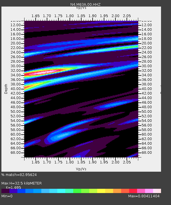
| Estimated Moho Depth: |
32.5 km |
| Estimated Crust Vp/Vs: |
1.70 |
| Assumed Crust Vp: |
6.472 km/s |
| Estimated Crust Vs: |
3.818 km/s |
| Estimated Crust Poisson's Ratio: |
0.23 |
|
| Radial Match: |
82.95624 % |
| Radial Bump: |
234 |
| Transverse Match: |
81.746155 % |
| Transverse Bump: |
370 |
| SOD ConfigId: |
18369291 |
| Insert Time: |
2019-05-30 16:27:12.194 +0000 |
| GWidth: |
2.5 |
| Max Bumps: |
400 |
| Tol: |
0.001 |
|

Signal To Noise
| Channel | StoN | STA | LTA |
| N4:M63A:00:HHZ:20190516T16:28:05.209999Z | 8.093485 | 2.1546264E-6 | 2.6621737E-7 |
| N4:M63A:00:HH1:20190516T16:28:05.209999Z | 4.1932664 | 1.0992651E-6 | 2.6215008E-7 |
| N4:M63A:00:HH2:20190516T16:28:05.209999Z | 2.7297268 | 5.6308414E-7 | 2.0627859E-7 |
| Arrivals |
| Ps | 3.8 SECOND |
| PpPs | 12 SECOND |
| PsPs/PpSs | 16 SECOND |


