You are here: Home > Network List > TA - USArray Transportable Network (new EarthScope stations) Stations List
> Station F21K Alatna River, AK, USA > Earthquake Result Viewer
F21K Alatna River, AK, USA - Earthquake Result Viewer
| Earthquake location: |
Near Coast Of Nicaragua |
| Earthquake latitude/longitude: |
12.6/-87.9 |
| Earthquake time(UTC): |
2019/05/16 (136) 16:22:16 GMT |
| Earthquake Depth: |
62 km |
| Earthquake Magnitude: |
5.9 Mww |
| Earthquake Catalog/Contributor: |
NEIC PDE/us |
|
| Network: |
TA USArray Transportable Network (new EarthScope stations) |
| Station: |
F21K Alatna River, AK, USA |
| Lat/Lon: |
67.22 N/153.48 W |
| Elevation: |
597 m |
|
| Distance: |
69.1 deg |
| Az: |
337.687 deg |
| Baz: |
107.859 deg |
| Ray Param: |
0.05573923 |
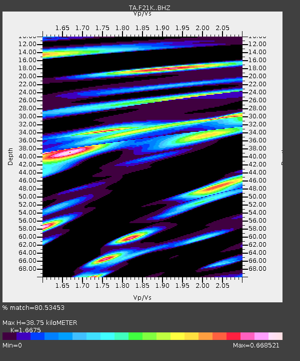
| Estimated Moho Depth: |
38.75 km |
| Estimated Crust Vp/Vs: |
1.67 |
| Assumed Crust Vp: |
6.455 km/s |
| Estimated Crust Vs: |
3.871 km/s |
| Estimated Crust Poisson's Ratio: |
0.22 |
|
| Radial Match: |
80.53453 % |
| Radial Bump: |
400 |
| Transverse Match: |
65.66126 % |
| Transverse Bump: |
400 |
| SOD ConfigId: |
18369291 |
| Insert Time: |
2019-05-30 16:28:43.875 +0000 |
| GWidth: |
2.5 |
| Max Bumps: |
400 |
| Tol: |
0.001 |
|
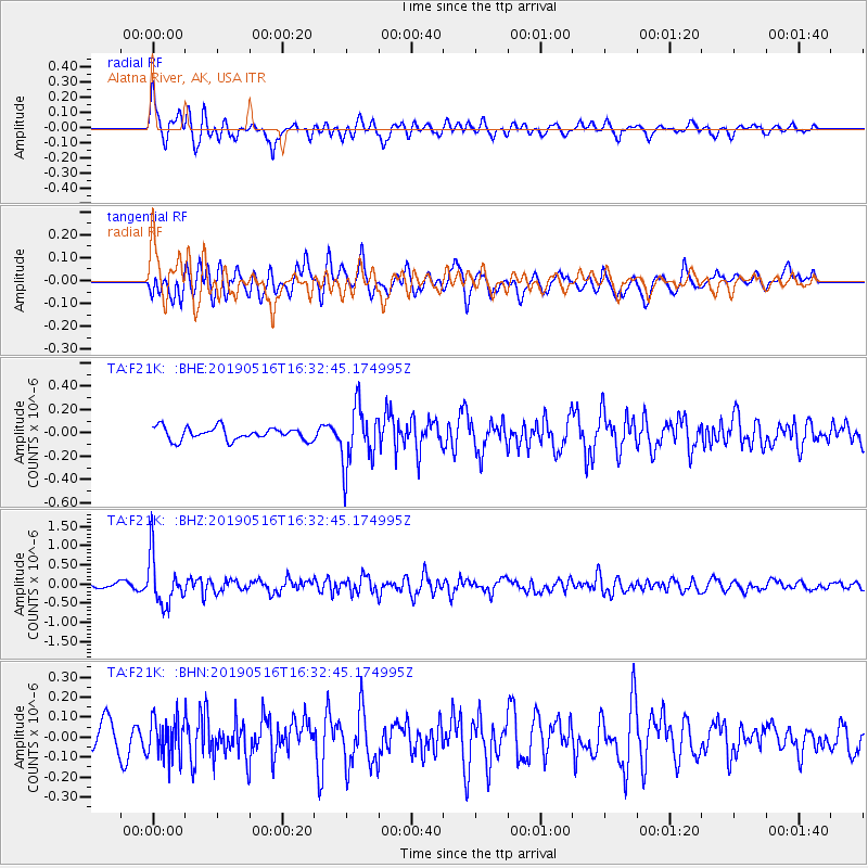
Signal To Noise
| Channel | StoN | STA | LTA |
| TA:F21K: :BHZ:20190516T16:32:45.174995Z | 6.8271227 | 6.3900177E-7 | 9.359753E-8 |
| TA:F21K: :BHN:20190516T16:32:45.174995Z | 2.0134394 | 9.745684E-8 | 4.8403166E-8 |
| TA:F21K: :BHE:20190516T16:32:45.174995Z | 4.70915 | 2.5523556E-7 | 5.419992E-8 |
| Arrivals |
| Ps | 4.2 SECOND |
| PpPs | 15 SECOND |
| PsPs/PpSs | 20 SECOND |


