You are here: Home > Network List > TA - USArray Transportable Network (new EarthScope stations) Stations List
> Station L20A Wamsutter, WY, USA > Earthquake Result Viewer
L20A Wamsutter, WY, USA - Earthquake Result Viewer
| Earthquake location: |
East Of Severnaya Zemlya |
| Earthquake latitude/longitude: |
81.6/119.5 |
| Earthquake time(UTC): |
2009/10/07 (280) 20:52:13 GMT |
| Earthquake Depth: |
8.0 km |
| Earthquake Magnitude: |
5.7 MB, 5.1 MS, 5.8 MW, 5.8 MW |
| Earthquake Catalog/Contributor: |
WHDF/NEIC |
|
| Network: |
TA USArray Transportable Network (new EarthScope stations) |
| Station: |
L20A Wamsutter, WY, USA |
| Lat/Lon: |
42.01 N/108.34 W |
| Elevation: |
2028 m |
|
| Distance: |
54.1 deg |
| Az: |
42.997 deg |
| Baz: |
352.242 deg |
| Ray Param: |
0.065633446 |
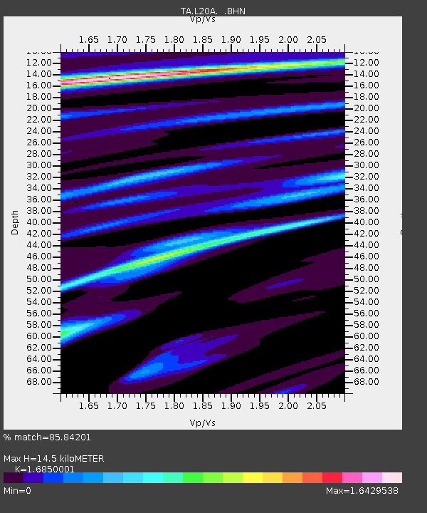
| Estimated Moho Depth: |
14.5 km |
| Estimated Crust Vp/Vs: |
1.69 |
| Assumed Crust Vp: |
6.161 km/s |
| Estimated Crust Vs: |
3.656 km/s |
| Estimated Crust Poisson's Ratio: |
0.23 |
|
| Radial Match: |
85.84201 % |
| Radial Bump: |
400 |
| Transverse Match: |
65.14699 % |
| Transverse Bump: |
400 |
| SOD ConfigId: |
2622 |
| Insert Time: |
2010-03-06 22:37:02.226 +0000 |
| GWidth: |
2.5 |
| Max Bumps: |
400 |
| Tol: |
0.001 |
|

Signal To Noise
| Channel | StoN | STA | LTA |
| TA:L20A: :BHN:20091007T21:01:07.525005Z | 5.851224 | 9.286694E-7 | 1.587137E-7 |
| TA:L20A: :BHE:20091007T21:01:07.525005Z | 3.402581 | 4.1352777E-7 | 1.2153356E-7 |
| TA:L20A: :BHZ:20091007T21:01:07.525005Z | 0.74175555 | 1.5516339E-7 | 2.0918401E-7 |
| Arrivals |
| Ps | 1.7 SECOND |
| PpPs | 6.0 SECOND |
| PsPs/PpSs | 7.7 SECOND |


