You are here: Home > Network List > TA - USArray Transportable Network (new EarthScope stations) Stations List
> Station L20A Wamsutter, WY, USA > Earthquake Result Viewer
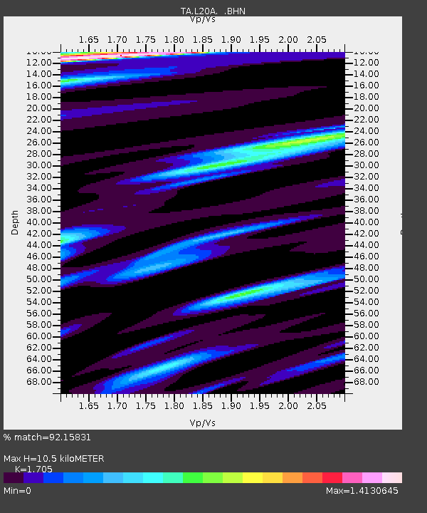
L20A Wamsutter, WY, USA - Earthquake Result Viewer
| Earthquake location: |
Windward Islands |
| Earthquake latitude/longitude: |
15.0/-61.3 |
| Earthquake time(UTC): |
2007/11/29 (333) 19:00:19 GMT |
| Earthquake Depth: |
148 km |
| Earthquake Magnitude: |
6.9 MB, 7.4 MW, 7.4 MW |
| Earthquake Catalog/Contributor: |
WHDF/NEIC |
|
| Network: |
TA USArray Transportable Network (new EarthScope stations) |
| Station: |
L20A Wamsutter, WY, USA |
| Lat/Lon: |
42.01 N/108.34 W |
| Elevation: |
2028 m |
|
| Distance: |
48.6 deg |
| Az: |
313.288 deg |
| Baz: |
109.275 deg |
| Ray Param: |
0.06874177 |
| Estimated Moho Depth: |
10.5 km |
| Estimated Crust Vp/Vs: |
1.71 |
| Assumed Crust Vp: |
6.161 km/s |
| Estimated Crust Vs: |
3.613 km/s |
| Estimated Crust Poisson's Ratio: |
0.24 |
|
| Radial Match: |
92.15831 % |
| Radial Bump: |
378 |
| Transverse Match: |
80.13418 % |
| Transverse Bump: |
400 |
| SOD ConfigId: |
2564 |
| Insert Time: |
2010-03-06 22:37:08.740 +0000 |
| GWidth: |
2.5 |
| Max Bumps: |
400 |
| Tol: |
0.001 |
|

Signal To Noise
| Channel | StoN | STA | LTA |
| TA:L20A: :BHN:20071129T19:08:17.500006Z | 4.7501645 | 2.4299577E-6 | 5.1155234E-7 |
| TA:L20A: :BHE:20071129T19:08:17.500006Z | 9.40904 | 4.093402E-6 | 4.3504988E-7 |
| TA:L20A: :BHZ:20071129T19:08:17.500006Z | 48.21307 | 1.7403678E-5 | 3.6097427E-7 |
| Arrivals |
| Ps | 1.3 SECOND |
| PpPs | 4.4 SECOND |
| PsPs/PpSs | 5.6 SECOND |


