You are here: Home > Network List > TA - USArray Transportable Network (new EarthScope stations) Stations List
> Station H27K Steamboat Mountain, AK, USA > Earthquake Result Viewer
H27K Steamboat Mountain, AK, USA - Earthquake Result Viewer
| Earthquake location: |
Near Coast Of Nicaragua |
| Earthquake latitude/longitude: |
12.6/-87.9 |
| Earthquake time(UTC): |
2019/05/16 (136) 16:22:16 GMT |
| Earthquake Depth: |
62 km |
| Earthquake Magnitude: |
5.9 Mww |
| Earthquake Catalog/Contributor: |
NEIC PDE/us |
|
| Network: |
TA USArray Transportable Network (new EarthScope stations) |
| Station: |
H27K Steamboat Mountain, AK, USA |
| Lat/Lon: |
66.23 N/141.53 W |
| Elevation: |
786 m |
|
| Distance: |
64.3 deg |
| Az: |
338.762 deg |
| Baz: |
119.262 deg |
| Ray Param: |
0.058838 |
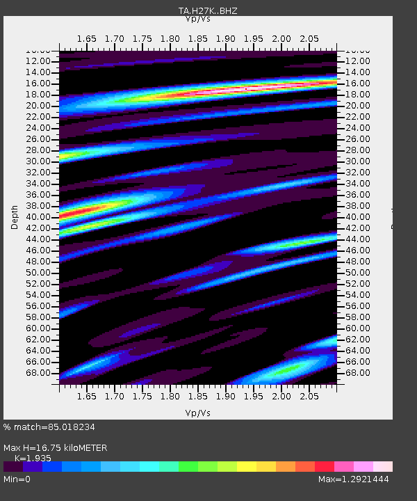
| Estimated Moho Depth: |
16.75 km |
| Estimated Crust Vp/Vs: |
1.93 |
| Assumed Crust Vp: |
6.577 km/s |
| Estimated Crust Vs: |
3.399 km/s |
| Estimated Crust Poisson's Ratio: |
0.32 |
|
| Radial Match: |
85.018234 % |
| Radial Bump: |
400 |
| Transverse Match: |
68.79509 % |
| Transverse Bump: |
400 |
| SOD ConfigId: |
18369291 |
| Insert Time: |
2019-05-30 16:29:00.761 +0000 |
| GWidth: |
2.5 |
| Max Bumps: |
400 |
| Tol: |
0.001 |
|

Signal To Noise
| Channel | StoN | STA | LTA |
| TA:H27K: :BHZ:20190516T16:32:15.049995Z | 6.2302446 | 7.7490347E-7 | 1.2437769E-7 |
| TA:H27K: :BHN:20190516T16:32:15.049995Z | 2.4252794 | 2.74847E-7 | 1.1332591E-7 |
| TA:H27K: :BHE:20190516T16:32:15.049995Z | 3.5694814 | 2.8763418E-7 | 8.05815E-8 |
| Arrivals |
| Ps | 2.5 SECOND |
| PpPs | 7.2 SECOND |
| PsPs/PpSs | 9.7 SECOND |


