You are here: Home > Network List > TA - USArray Transportable Network (new EarthScope stations) Stations List
> Station L20A Wamsutter, WY, USA > Earthquake Result Viewer
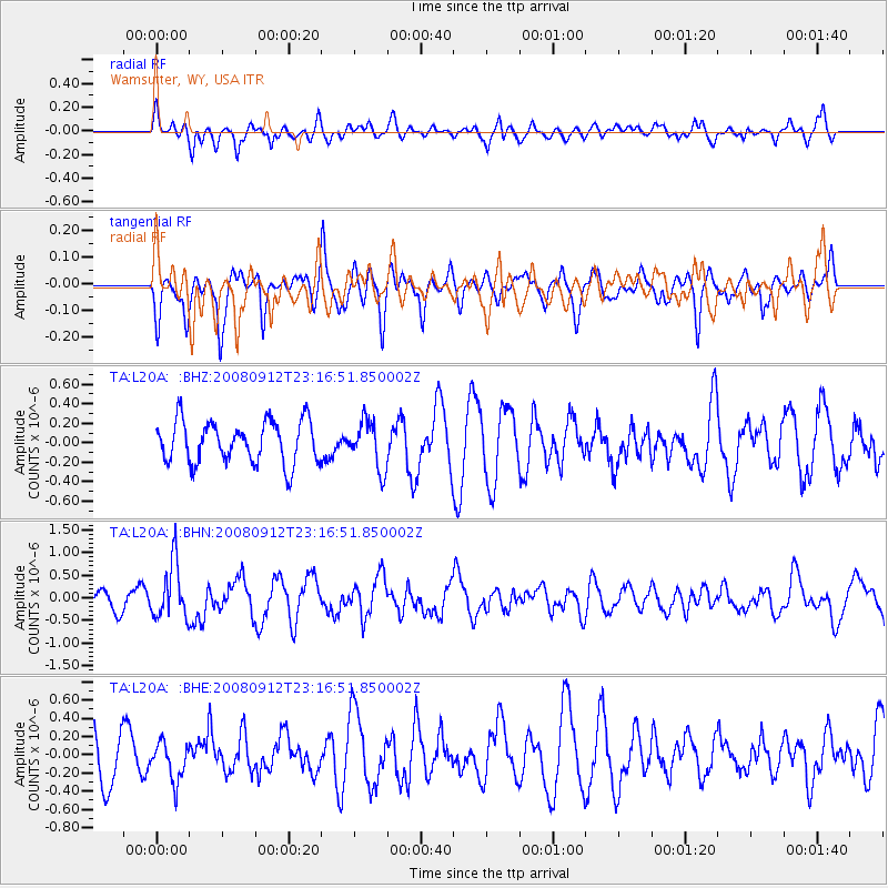
L20A Wamsutter, WY, USA - Earthquake Result Viewer
*The percent match for this event was below the threshold and hence no stack was calculated.
| Earthquake location: |
Komandorskiye Ostrova Region |
| Earthquake latitude/longitude: |
56.3/164.1 |
| Earthquake time(UTC): |
2008/09/12 (256) 23:07:50 GMT |
| Earthquake Depth: |
9.3 km |
| Earthquake Magnitude: |
5.5 MB, 5.7 MS, 5.9 MW, 5.9 MW |
| Earthquake Catalog/Contributor: |
WHDF/NEIC |
|
| Network: |
TA USArray Transportable Network (new EarthScope stations) |
| Station: |
L20A Wamsutter, WY, USA |
| Lat/Lon: |
42.01 N/108.34 W |
| Elevation: |
2028 m |
|
| Distance: |
55.2 deg |
| Az: |
65.117 deg |
| Baz: |
317.282 deg |
| Ray Param: |
$rayparam |
*The percent match for this event was below the threshold and hence was not used in the summary stack. |
|
| Radial Match: |
54.44315 % |
| Radial Bump: |
400 |
| Transverse Match: |
56.483574 % |
| Transverse Bump: |
400 |
| SOD ConfigId: |
2560 |
| Insert Time: |
2010-03-06 22:37:35.990 +0000 |
| GWidth: |
2.5 |
| Max Bumps: |
400 |
| Tol: |
0.001 |
|
Signal To Noise
| Channel | StoN | STA | LTA |
| TA:L20A: :BHN:20080912T23:16:51.850002Z | 2.995993 | 6.105983E-7 | 2.03805E-7 |
| TA:L20A: :BHE:20080912T23:16:51.850002Z | 0.7866635 | 2.1158469E-7 | 2.689647E-7 |
| TA:L20A: :BHZ:20080912T23:16:51.850002Z | 1.1392121 | 2.4442087E-7 | 2.1455254E-7 |
| Arrivals |
| Ps | |
| PpPs | |
| PsPs/PpSs | |


